ForestHD: Harvest, Deforestation and Degradation Detection
A European Space Agency funded initiative.
Current compliance tools can’t tell the difference between legal timber harvesting and illegal forest clearing. NGIS is partnering with the European Space Agency to build a tool that can.
When Legal Harvesting Looks Like Deforestation
The European Union Deforestation Regulation (EUDR) was designed to stop illegal forest clearing, but for the timber industry, forest clearing is part of the natural business cycle.
The EUDR is a law that restricts operators from placing products on the EU market that are linked to deforestation or degradation. Coming into effect December 30th, 2026, timber operators, as well as a few other select commodities, will need to provide precise geolocation information of plantations that serve as the source of their raw materials, establish a robust internal due diligence system to prove that their timber is legal and deforestation-free and complete due diligence statements upon each import and export to the European Union.
Automated satellite-based systems are the only approach which can deliver required monitoring and reporting on large timber operations which span thousands of square kilometres. Designing and building a timber-specific degradation monitoring suite will allow this monitoring to be delivered within a timeframe that is useful to identify shipments as deforestation/degradation free before they hit European ports. But that’s not the only challenge timber operators face.
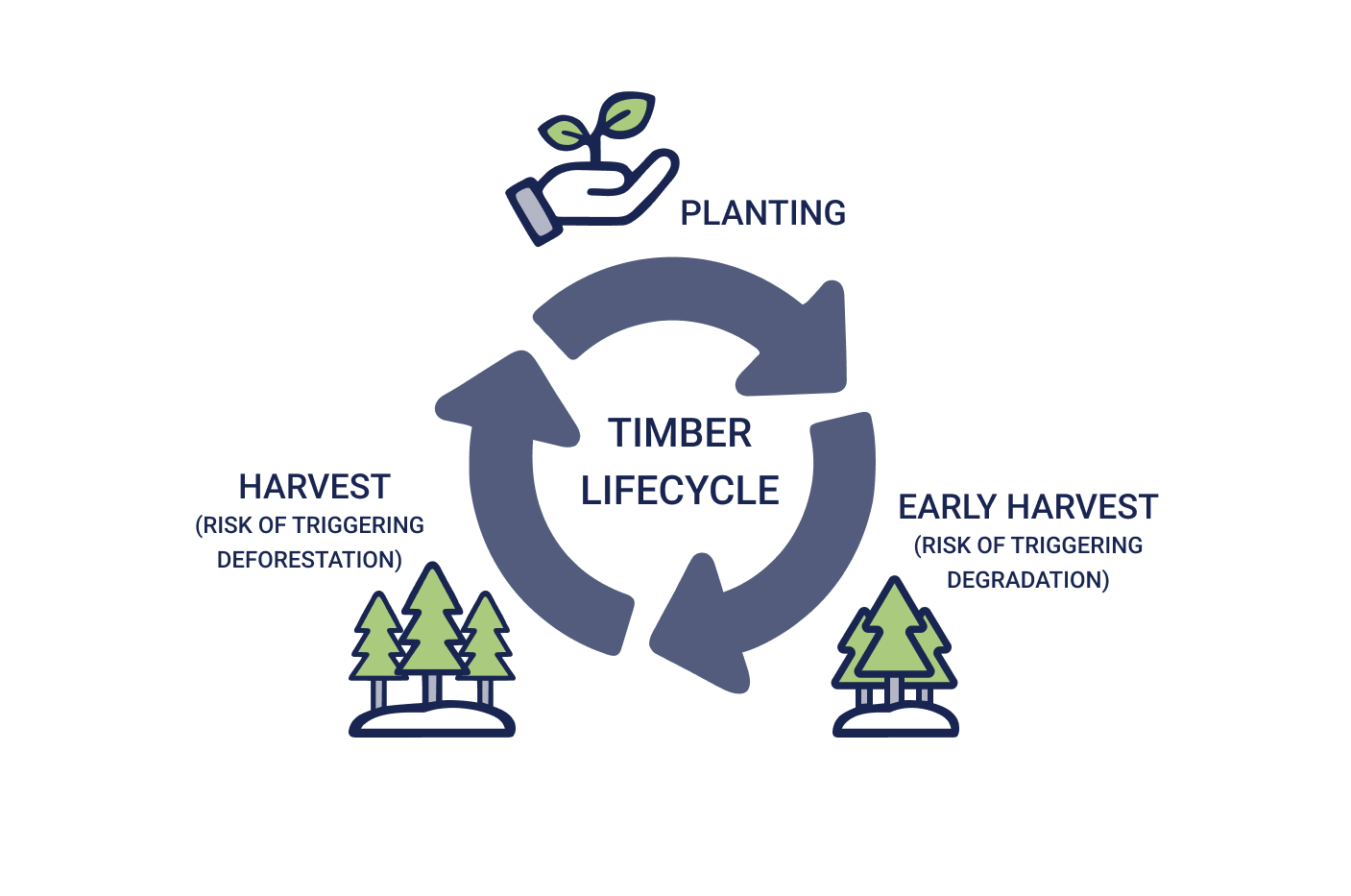
Harvest looks like deforestation
When a timber company harvests its trees, automated satellite monitoring systems detect tree loss and flag it as a deforestation event. Legal, sustainable harvesting is flagged as a false positive alert for illegal clearing by satellite-based monitoring systems that only use tree-loss as deforestation metric. Each event requires manual review, creating operational inefficiencies that put pressure on teams, that no manual process can sustainably absorb.
Tree thinning looks like degradation
While “degradation” has a dictionary definition, it lacks a precise scientific benchmark and internationally agreed methodology to measure it. This makes it incredibly difficult for timber companies to comply with the new laws as there is no scientific consensus to measure degradation from standard timber business cycles, so each company has their own practices to report on this. We intend to improve this fragmented landscape by developing a scientifically robust methodology that can be used across the industry.
Traceability
Forest HD, a TraceMark module solution for timber operators
TraceMark provides an automated, data driven end to end platform for EUDR compliance. It is built on Google Cloud Platform that has been specifically designed for large enterprises with complex global supply chains. Leveraging Google’s enterprise-grade security and compliance infrastructure, TraceMark provides secure single tenant deployment that enables workflows, datasets and integrations to be tailored specifically for businesses seeking a high value, seamless implementation of raw material traceability.
Powered by Google’s AI and machine learning capabilities, TraceMark provides a system of record for supplier engagement and workflow generation for proactive alerting on risk against portfolios.
ForestHD is a dedicated TraceMark module that will support timber operators distinguish legal timber operations from true deforestation and degradation events.
What’s in Development
Make better decisions with better information. Understand what is happening on the ground in the areas you care about. Power your decision making with Planet’s unique, global dataset.
Harvest Detection
By overlaying known harvest operation sites against satellite-detected tree loss events, ForestHD will automatically classify legal harvest activity. For areas with incomplete data, NGIS are developing additional parameters.
Degredation Metrics
Drawing on peer-reviewed scientific research and satellite data, NGIS is building a framework to detect and quantify forest degradation.
Polygon Cleaning
Geospatial data collected locally by non-geospatial experts frequently arrives with significant errors. NGIS is exploring automated ways these errors can be identified and corrected within agreed parameters.
European Space Agency
This work was carried out under a programme of, and funded by, the European Space Agency. ESA Contract No. 4000150382/25/UK/AL/ka.
The views expressed herein can in no way be taken to reflect the official opinion of the European Space Agency.
Project Timeline
Partner with NGIS
We are a leading global geospatial solution provider that seeks to better the world through the power of maps and data. In 2026, we joined Collecte Localisation Satellites (CLS), a global leader in monitoring and surveillance solutions for our Earth.
If you’re a timber supplier working through EUDR compliance and looking for support, our team would love to help.
Newsroom
Using the power of geospatial, NGIS is committed to enacting positive change for businesses, communities, and individuals, globally. Read our blogs to discover more about the work we do.
How Satellite based Earth Observation Supports Emergency Response Teams
Natural disasters are an increasingly familiar reality, yet their unpredictability remains a core challenge. This is why preparedness is our best means of mitigating impact when disaster does occur. Satellite technology plays a critical role in enabling this readiness, but why? To understand this, you need only consider the sheer scale and diversity of Australia’s landscapes, waters and ecosystems. The continent spans 7.7 million square kilometres and, relative to its total area, has a low population density. This…United Nations, Google Cloud and NGIS Team Up to Bring AI-Powered Planning to Communities in Crisis
The United Nations International Organization for Migration (IOM), in partnership with Google Cloud and NGIS are advancing data-driven humanitarian planning through the use of AI and Geospatial powered tools, helping humanitarian organisations to analyse the most vulnerable locations across multiple areas and proactively plan for disaster response, climate driven displacement, and long term community recovery. At the centre of the initiative is the…Celebrating Women in GIS: More than Maps
From tracking deforestation to building geospatial tools from the ground up, the women at NGIS are driving impactful real-world outcomes. This International Women’s Day, we spoke to three women across our Earth Observation, software engineering and spatial analysis solutions, to find out what first attracted them to GIS, what keeps them here, and what they’d tell their younger selves starting out.NGIS joins global space-based solutions provider CLS
Media Release | 27th January 2026 NGIS is excited to announce that the company will now be part of CLS (Collecte Localisation Satellites), a global leader in monitoring and surveillance solutions for our Earth. The acquisition marks a significant milestone for the Australian geospatial sector, bringing together NGIS’ world-class geospatial expertise with CLS Group’s expansive reach and innovative capabilities in space-based solutions. Beyond technology and commercial…


