Water information reporting

Removing barriers to getting water information
Western Australia is a large state and the Department of Water manages the water resource for all stakeholders.The Department wanted to improve its system for handling requests from industry and members of the public for reports on water sources, from bore holes to floodplains and everything in between. A human-driven system that needed a tendered request to be fulfilled manually meant response times were slower than customers wanted.
The department recognised an opportunity to improve information flow and delivery times and engaged NGIS to develop a self-service tool that would radically change response times and make it easier for members of the public to quickly find information they needed to make a decision.

Self service for water information
The Department of Water (DoW) supports Western Australia’s growth, facilitates state development, meets environmental needs, and fosters community and cultural benefits by monitoring and managing the availability and quality of water sustainability.
NGIS partnered with the Department of Water (DoW) to build an online GIS solution providing a self-service system any public user can easily use to access all information requirements regarding water. Using Microsoft SharePoint 2010 with an existing ArcGIS system, the new Water Information Reporting (WIR) is an easy to use site that helps to contribute to the environmental management of Western Australia’s growing water needs.
Online GIS water information reporting solution
NGIS was engaged to develop a solution architecture for an intranet/internet based system that could deliver functionality to reduce the impact on DoW’s resources. NGIS’ brief was to convert a time consuming manual process of extracting datasets of information into a self-service process that provides DoW’s clients with an easy to use system that gives instant access to their water information requests.
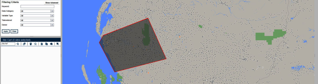
The main objective of the Water Information Reporting (WIR) system is to provide a user the ability to select one or more sampling sites (up to 1000 sites) using a combination of spatial and non-spatial criteria. Once a selection has been made, the user can request specific information for the selected sites.

Leveraging automated workflows
In designing a solution for WIR, modularity has been a guiding principle for NGIS. To maximise the flexibility of the system to change over time, service-orientated architecture was employed. Microsoft SharePoint 2010 server has been used to provide a robust, secure and flexible platform integrated with existing ESRI ArcGIS and Microsoft SQL server Integration Services technology. The Microsoft SharePoint site is the central element of the solution. It provides both public and Department of Water (DoW) users access to the site and data selection interface. Furthermore it provides DoW administrators a method to configure and manage via a simple interface.
The combination of Microsoft SharePoint 2010, ESRI ArcGIS Server, Microsoft SQL Server Integration and Reporting Services was a perfect match to leverage automated workflows, intranet and public internet site publishing capabilities, data reporting, geoprocessing services, and automated extract, transform and load processing (ETL).