A Smarter Way to Manage Western Australia’s Roads

NGIS has partnered with Main Roads Western Australia (MRWA) to design and deliver the Real Time Operations Platform (RTOP), a next-generation, map-centric operational platform that is transforming how Western Australia’s road network is monitored and managed in real-time.
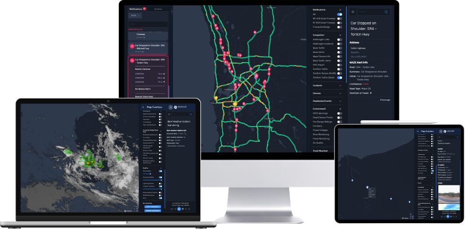
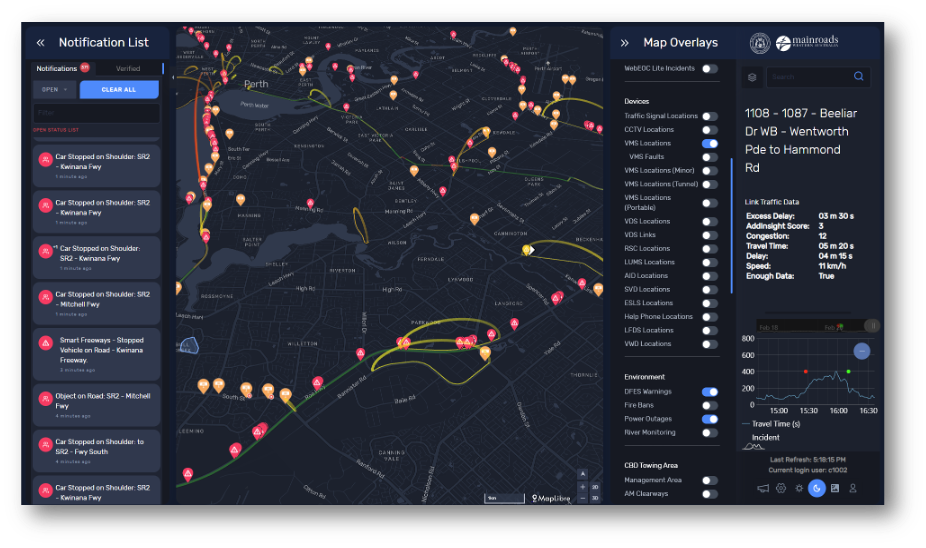
RTOP integrates data from 28 internal and third-party systems into a single operating picture, enabling faster decision-making, improved incident response, and more reliable journeys for millions of road users every day.
The Challenge
Western Australia manages the largest road network in the country, spanning 19,000 kilometres of state roads across vast distances. From the operations centre in Perth, Western Australia and regional support centres state-wide, Main Roads can oversee:
- More than 4 million private vehicle trips daily
- A metropolitan area extending over 150 kilometres
- Thousands of data streams from roadside devices and third-party providers
While ample amounts of operational data were available, it was fragmented across multiple systems, many of which were non-spatial. For Real Time Traffic Operators, this meant constantly switching between platforms, duplicating searches, and losing spatial context- all while time-critical incidents unfolded.
Delays in detecting and responding to incidents can significantly increase congestion, emissions, and economic cost. Infrastructure Australia has projected that congestion in Perth could cost $3.6 billion by 2031 if left unmanaged.
Main Roads had a clear vision: one platform to drive a highly responsive, predictable, streamlined and advanced road network.
The Solution
Main Roads engaged NGIS to design and implement the RTOP, a dashboard built specifically for control room workflows.
RTOP brings together real-time data streams from 28 disparate systems, spatially allowing them to provide:
- Live incident visualisation
- Location-based alerts and notifications
- Decision support in a single, common operating picture
Rather than functioning as a traditional GIS with layers, RTOP enhances the map by creating editable, prioritised notifications where business rules indicate conditions requiring operator intervention.
How does it work?
RTOP absorbs and processes both spatial and non-spatial data, including:
- Roadside devices (CCTV, Variable Message Signs (VMS), lane management signs, traffic signals)
- Third-party services (such as Waze)
- Emergency services alerts (e.g. the Western Australian Department of Fire & Emergency Services (DFES) bushfire alerts)
- Weather, tide, wind, and visibility conditions
- Incident management systems
- Policy-driven operational rules and Standard Operating Procedures embedded directly into the platform
Key capabilities include:
- Location-based alerts for incidents, abnormal traffic conditions, and device outages – allowing faster detection and response
- Grouping and prioritisation of related alerts to reduce noise -minimising operator overload
- Geocoding of non-spatial records to maintain spatial context – ensuring no incident loses its location relevance
- Proximity analysis to nearby devices, incidents, and hazards – supporting informed, immediate action
- Editable notifications linked directly to incident management workflows – streamlining response processes
- Map-based situational awareness without requiring advanced GIS skills – empowering all operators to act confidently
The result is a fast interface that allows operators to assess situations, respond and communicate all from one platform.
Outcomes
The implementation of RTOP has delivered measurable improvements across operations, efficiency, and user experience.
For Operators
For operators within the Road Network Operations Centre, RTOP has transformed day-to-day network management. By consolidating 28 disparate systems into a single, map-centric platform, operators now have a unified, real-time view of incidents, traffic conditions, device status, and external influences. Automated alert prioritisation, spatial grouping, and integrated workflows reduce system switching and manual processes, enabling faster assessment and response. The result is improved situational awareness, more proactive incident management, and greater confidence in decision-making under time-critical conditions.
For Main Roads WA
For Main Roads Western Australia, RTOP delivers a common operating picture that strengthens both tactical operations and strategic performance management. The platform supports faster incident resolution, improved network reliability, and earlier intervention to reduce congestion impacts. Enhanced reporting and operational insights enable continuous improvement and long-term planning, while full adoption within the control room environment demonstrates measurable organisational value. RTOP establishes a scalable foundation for predictive capabilities, automation, and future network innovation.
“Our focus has been on moving beyond simply monitoring data to genuinely mastering the complexity of the network. Through our partnership with NGIS in delivering the Real Time Operations Platform (RTOP), we’ve brought multiple systems together into a single, intuitive operating view. It represents a step change in how we operate and assists our Realtime Network Operations Centre to support safer, more reliable journeys for all Western Australians.”
Conclusion
Since its implementation, RTOP has not only improved operational efficiency but also changed the way Main Roads Western Australia approaches road network management. By merging fragmented data and providing operators with a clear, actionable view, the platform has enabled faster responses, smarter decisions, and a more proactive management of incidents.
By enabling faster detection and response to incidents, RTOP supports reduced congestion impacts, improved network reliability, and safer journeys for millions of Western Australians who rely on the road network every day.


