How NGIS helped streamline the NSW road reclassification

Streamlining the NSW road reclassification
Transport for NSW (TfNSW) is the leading government agency within the New South Wales (NSW) transport sector. Its role is to “lead the development of a safe, efficient, integrated transport system that keeps people and goods moving, connects communities and shapes the future of our cities, centres and regions.” In 2019 the Deputy Premier and then Minister for Roads, Maritime and Freight made the commitment to initiate a Road Classification Review and to transfer up to 15,000km of regional roads to State accountability to better support local councils by managing and maintaining the rural road network . Due to the major re-classification, an Independent Panel was assembled to provide advice and undertake holistic assessments of the potential and proposed nominations received primarily from local councils. The Panel was required to make recommendations about any potential long term impacts on local and State governments, especially regarding complex applications.
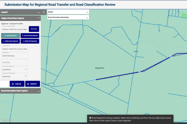
NGIS delivered a web-based mapping application to TfNSW which accepts applications for road network reclassifications from local councils across NSW. Applications are then passed on to the Panel for consideration.
What was the catalyst for the project?
Prior to TfNSW building an online tool, proposed road re-classifications were completed manually with significant assistance of an in-house Project Officer. Some applicants used highlighter pen on printed maps and attached the maps to their applications. The Project Officer then manually transferred the data to a bigger, digitised map for the Independent Panel to understand the road network impact. As newly proposed re-classifications cover the entire state, this was a lengthy task with opportunities for data entry error. TfNSW sought a more streamlined and efficient solution and enlisted the help of NGIS.
What did NGIS build to classify the network?
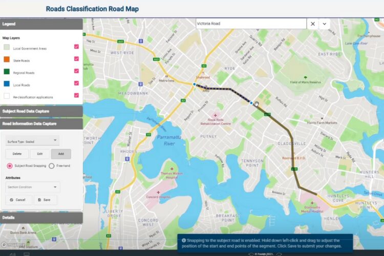
In collaboration with TfNSW, NGIS senior team members worked closely to develop a browser based application for capturing roads and numerous attributes in a spatial format. This application is called the Roads Classification Review Map (RCRM). The RCRM is a public-facing application that enables LGA representatives and TfNSW staff to view, create, edit road classifications and road transfer assessment process across NSW from any location via a web browser. RCRM contains features such as drop pins for culverts, annual daily traffic measures, road surface conditions, detours in addition to other customisable elements to suit the needs of the user. The attributes being collected for the LGA proposed re-classifications will allow for the Panel to make comprehensive decisions on the ownership of the road, with all of the relevant information laid out visually.
The result is a platform that replaces the TfNSW led manual editing process previously required to capture reclassification requests and distributes this workload via the platform to the councils themselves. Now, local government councils can easily and simply input these requests themselves, rather than passing them on to TfNSW to handle. In turn, when the Panel makes their assessments, there are layers of data displayed in a user-friendly map format that visually supports the decision making process.
NGIS were very good at accommodating our requirements which evolved as the project progressed. There was an increase in scope and they were supportive with that…”
Chris Wong, Project Officer.
How did our work benefit the agency?
With the addition of this software, the operational teams at TfNSW now have a way to easily continue their classification-related tasks as their role has become one of managing and assisting councils and other end users in capturing re-classification data rather than undertaking data input themselves. Chris Wong, Project Officer said “The platform the NGIS team developed is very intuitive and easy to navigate. NGIS were very good at accommodating our requirements which evolved as the project progressed. There was an increase in scope and they were supportive with that…The RCRM is very helpful when inputting GIS data; the software is working well.”
This project is an excellent example of how spatial technology can better support local and state government decision making which ultimately benefits the community. It highlights the potential for the use of interactive and digital mapping tools in initiatives involving multiple public sector stakeholders.
If you are interested in talking to one of our team about how we can help with your upcoming project, reach out below.


