Teaching Conservation at the Heart of the Coral Triangle


When the classroom becomes a coral reef
This past summer, I returned to a remote corner of Indonesia, the Wakatobi Marine National Park. The National Park sits at the epicentre of the Coral Triangle, home to the highest marine biodiversity on Earth.
However, this time, I wasn’t there as a researcher or on holiday. Instead, I was teaching the next generation of scientists, showing them how geospatial technology can work hand-in-hand with marine conservation.
A 15-Year Journey
My connection to the National Park began 15 years ago as an undergraduate Zoology student conducting thesis research on pristine coral reefs.
I was captivated by the opportunity to work in such a remote location and learn from the Sampella Bajau community, an indigenous people whose entire culture revolves around the sea, living in stilt villages built over the water.
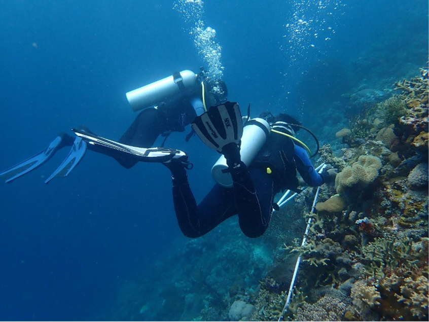
Last year, my family and I returned for a visit, reconnecting with old friends. This year was different. From late June to July 2025, I served as Scientific Divemaster at the Hoga Island Marine Station, part of Operation Wallacea’s research program that has produced over 200 peer-reviewed papers in nearly 30 years.
From Researcher to Educator
My role included teaching volunteers from around the world (such as students from UK, Singapore, Belgium, Australia, and New Zealand) how to conduct rigorous marine research. This meant training them in scientific diving, coral reef ecology, species identification, and survey techniques, including benthic transects and monitoring of the Mars Assisted Reef Restoration System.
However, I felt there was an opportunity to offer something additional: to show these future scientists how the work we do at NGIS directly improves conservation outcomes globally. In my weekly lectures on data analysis for conservation, I demonstrated how satellite imagery and Earth Observation technologies extend field research.
The underwater surveys students conducted, vital as they were, represented localised data points. Geospatial analysis reveals the larger patterns, tracking seagrass biomass across vast areas, monitoring deforestation in supply chains, and providing key insights into biodiversity and the risks it faces globally, biodiversity and the risks it faces, empowering those making the most impactful decisions.
I shared examples of NGIS projects addressing sustainability challenges across industries, from fashion supply chain transparency to coffee traceability to palm oil certification. The fundamental tools remain consistent: spatial data analysis, remote sensing, risk assessment, and evidence-based decision-making. These same approaches inform effective marine conservation.
The students were working at one of Earth’s most biodiverse locations, but the threats these reefs face, climate change, ocean warming, biodiversity loss, demand both local action and global perspective. I wanted them to understand that impactful conservation happens in the field and in sophisticated data analysis platforms.
The Human Side of Conservation

Equally important was conveying that conservation isn’t just about data, it’s about people. The Wakatobi program operates in partnership with local communities.
Over the decades, former bomb fishermen and coconut farmers have become rangers, dive guides, and research assistants. This transformation demonstrates that when science is supported in community, it becomes sustainable.
Students witnessed this firsthand, interacting with Bajau community members and learning how traditional marine knowledge complements scientific research. My six-year-old daughter participated in shore-based conservation work and spent loads of time with children of local families as well as of other volunteers, a living example of the cross-cultural collaboration essential to future conservation efforts.
Teaching the Scientists of the Future
This was challenging work, managing students with varying experience levels, multiple dives daily, ensuring both safety and scientific rigor. But the rewards were extraordinary: watching students develop confidence underwater, grasp complex ecological relationships, and begin thinking about how to incorporate spatial analysis into their own research.
The data these students collected contributes to a 15-year monitoring program tracking changes in the Wakatobi’s reefs and informing management decisions. But equally valuable was developing a cohort of conservation scientists who understand that addressing environmental challenges requires integrating multiple approaches.


A Professional Perspective
This experience reinforced what we know at NGIS: the most effective solutions emerge when we combine local expertise with global tools, traditional knowledge with cutting-edge technology, and field observation with satellite data. The next generation of conservation scientists will need to be as comfortable analysing Earth Observation data as they are conducting underwater surveys.
The Coral Triangle faces serious challenges, such as ocean warming, coral bleaching, and habitat degradation. But working with passionate students, witnessing research-community partnerships, and seeing commitment to both active restoration and long-term monitoring gave me tremendous hope.
The skills I’ve developed at NGIS, understanding how geospatial technology addresses complex sustainability challenges, communicating technical concepts to diverse audiences, and recognising that impactful solutions require collaboration across disciplines, have proved directly applicable to conservation education. The students I worked with this summer represent the future of science-based environmental stewardship, and I’m honoured to have contributed to their development.
If they’re any indication of what’s coming, we’re in excellent hands.
Interested in applying satellite data, remote sensing, and spatial analysis to your sustainability or environmental challenges?
Download a copy of the latest NGIS Impact Report:
By Shawna Sanfey, Principal Consultant in EO, NGIS
Related Articles
Here are more related articles you may be interested in.
United Nations, Google Cloud and NGIS Team Up to Bring AI-Powered Planning to Communities in Crisis
The United Nations International Organization for Migration (IOM), in partnership with Google Cloud and NGIS are advancing data-driven humanitarian planning through the use of AI and Geospatial powered tools, helping humanitarian organisations to analyse the most vulnerable locations across multiple areas and proactively plan for disaster response, climate driven displacement, and long term community recovery. At the centre of the initiative is the…Celebrating Women in GIS: More than Maps
From tracking deforestation to building geospatial tools from the ground up, the women at NGIS are driving impactful real-world outcomes. This International Women’s Day, we spoke to three women across our Earth Observation, software engineering and spatial analysis solutions, to find out what first attracted them to GIS, what keeps them here, and what they’d tell their younger selves starting out.NGIS joins global space-based solutions provider CLS
Media Release | 27th January 2026 NGIS is excited to announce that the company will now be part of CLS (Collecte Localisation Satellites), a global leader in monitoring and surveillance solutions for our Earth. The acquisition marks a significant milestone for the Australian geospatial sector, bringing together NGIS’ world-class geospatial expertise with CLS Group’s expansive reach and innovative capabilities in space-based solutions. Beyond technology and commercial…The view from the Cuipo Tree: Rethinking Biodiversity Beyond Protected Areas
Biodiversity Biodiversity is often discussed in abstract terms, percentages protected, species at risk, and hectares conserved. Ecological networks operated at vast and local spatial scales. It lives at the intersection of forests and farms, rivers and roads, protected areas and working landscapes. Geospatial intelligence allows us to see these intersections clearly: to understand where species…


