Monitoring the disappearing underwater forest
What if one of the most critical ecosystems in our oceans was vanishing before our eyes without us even noticing? 95% of Tasmania’s kelp forests have vanished. Along Australia’s southern coastline, Giant Kelp forests, known for their towering underwater canopies and vital role in marine biodiversity, are quietly disappearing.
NGIS is proud to be part of the Giant Kelp Forest Restoration Partnership, a groundbreaking initiative launched by The Nature Conservancy (TNC) in mid-2023 to address the urgent decline of giant kelp forests. This collaboration unites key leaders in kelp restoration, including the Institute for Marine and Antarctic Studies (IMAS) at the University of Tasmania, Natural Resource Management South (NRM South), CSIRO, Google, and NGIS.
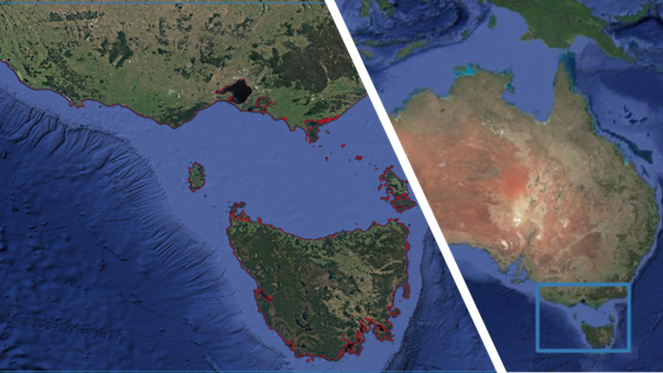
Using AI, geospatial data and mapping technology, researchers identified and analysed declining Kelp forests across more than 7000km2 of Planet satellite imagery along the coasts of Victoria and Tasmania. This analysis of Earth Observation (EO) data enabled rapid identification of Kelp forests and the development of an efficient, reliable, and long-term monitoring strategy for this critical marine ecosystem, which is increasingly threatened by climate change.
The Impact of Climate Change on Ecosystems
In many ecosystems, these changes force animal species to migrate and vegetation species to appear or disappear. Such shifts can result in habitat loss and competition with native species, leading to further ecological imbalances. Protecting ecosystems from the effects of climate change is essential to preserve biodiversity and maintain the processes that support life on Earth.
Regulators and the media have focused much on terrestrial ecosystems, particularly forests. Forests are vital in supporting biodiversity, sustaining ecosystems, and acting as natural buffers against climate change. However, oceanic ecosystems are also facing severe impacts. For instance, rising ocean temperatures cause coral bleaching, threatening marine biodiversity.
One lesser-known but equally alarming example of oceanic ecosystem decline is the silent disappearance of underwater Giant Kelp forests.
Mapping Southern Australia’s Giant Kelp Forests

Giant Kelp is a fast-growing brown seaweed found in underwater forests along coastlines. It is ecologically significant, supporting marine biodiversity, and has practical uses in food, fertilisers, and industrial products. Unfortunately, the presence of Kelp is shrinking due to rising sea temperatures and other environmental pressures.
Using Earth Observation technologies and Machine Learning models, NGIS and its partners mapped the extent of Kelp canopies along over 7,000 km² of the coastline of Victoria and Tasmania. This data allowed researchers to detect changes and track trends in Kelp forest distribution over time.
Example: Extension of the Area of interest in red. The entire coast of Tasmania and southern Victoria
Challenges of Mapping Kelp
The main challenge of mapping Kelp using EO data is that it is only visible when it breaks the surface of the water. On top of this, the ocean is an unpredictable environment: changing tides, winds, and waves introduce noise in the imagery observed, making the detection of Kelp much more complex compared to vegetation on land.

Add a short, consistent heading for your image.
Example: A PlanetScope false-color composite image over Actaeon Island in Tasmania shows Kelp as a thin red sliver on the northwest side, representing the canopy breaking the water’s surface.
Thanks to the ability of our partner Planet’s daily satellite imagery, yearly maps of Kelp were generated from 2016 until 2023.
While Kelp presence fluctuates yearly, the long-term data of our study found a visible declining trend of the total amount of Giant Kelp canopy. Below is an example of the Kelp canopy visible over Actaeon island in 2017, 2019, 2021, and 2023
Example: Kelp was detected in different years (2017, 2019, 2021, and 2023) around Actaeon Island in Tasmania. Negative trends of Giant kelp extent were evident from the data analysed.
This study not only underscores the significant decline of Giant Kelp forests along the Tasmanian and South Victorian coastlines over the past decade but also provides a strong framework for future monitoring.
Turning Data into Action
Climate change is driving the silent disappearance of underwater ecosystems like Giant Giant Kelp Forests. By leveraging Earth Observation technologies and Machine Learning models, this study has successfully mapped over 7,000 km² of Kelp canopy along the coasts of Victoria and Tasmania and identified trends in their decline.
This work forms the foundation for ongoing monitoring and contributes to broader conservation efforts led by The Nature Conservancy and Google. Together, these initiatives aim to safeguard the future of these vital underwater forests.
More details can be found here.
Related Articles
Here are more related articles you may be interested in.


