How Fire and Emergency Services are accessing satellite imagery acquired Australia-wide everyday, to prepare for and mitigate the impacts of the Bushfire Season


“It’s the biggest risk we’ve faced since the 2019-20 fire season,” New South Wales Rural Fire Service Commissioner, Rob Rogers – Sky News, September 2023.
With the Bureau of Meteorology declaring in September that Australia was now in an El Niño climate pattern, Eastern parts of Australia are likely to experience an “increased risk” of bushfires due to forecasts of above-average temperatures, decreased rainfall, high fuel loads and changing weather patterns, according to the Australasian Fire Authorities Council (AFAC) outlook.
Record-breaking September temperatures have seen bushfires occurring in New South Wales, Queensland and Tasmania at the onset of the bushfire season, all but validating the risk forecasts and prompting calls from State Government officials and emergency management authorities to prepare for intensifying conditions.
The Black Summer fires in 2019/2020 are among the worst Australia has seen, costing Australian agriculture between $4 billion and $5 billion. NGIS responded to several disaster events with spatial analysis and earth observation solutions, enabling responding agencies to identify, monitor and analyse the events to improve coordination and decision-making. Today, visualising imagery of an affected area from a bird’s eye view allows for a comprehensive understanding of the scope and severity of disasters such as bushfires. This information can be used to make more informed decisions about evacuation routes, emergency response efforts, and potential damage assessments in real-time; however, daily monitoring of Australia’s entire landmass makes it possible for pre-, during and post-event temporal analysis.
Our imagery partner Planet, provides timely and analysis-ready satellite imagery, useful for bushfire planning and response. Founded in 2010 by three NASA scientists, Planet designs, builds, and operates the largest commercial Earth observation fleet of imaging satellites, capturing over 30TB of data daily. Planet currently operates two satellite constellations: Dove satellites, which provide a daily scan of all the Earth’s landmass at three-metre resolution, and SkySat tasking satellites, which capture tasked images at 50cm resolution of any location on Earth on-demand.
The advantage of these two constellations is that they offer imagery when needed almost anywhere in Australia. Together with NGIS’s geospatial solutions and Planet’s data, we make timely information from space visible, accessible, and actionable. With tools such as Planet’s Explorer search and discovery interface and Stories timelapse viewer, NGIS is assisting agencies in viewing imagery faster – before, after and during bushfire events. For more information on how NGIS can help your organisation with Planet imagery, click here. View bushfire events we’ve observed from Planet’s imagery below.
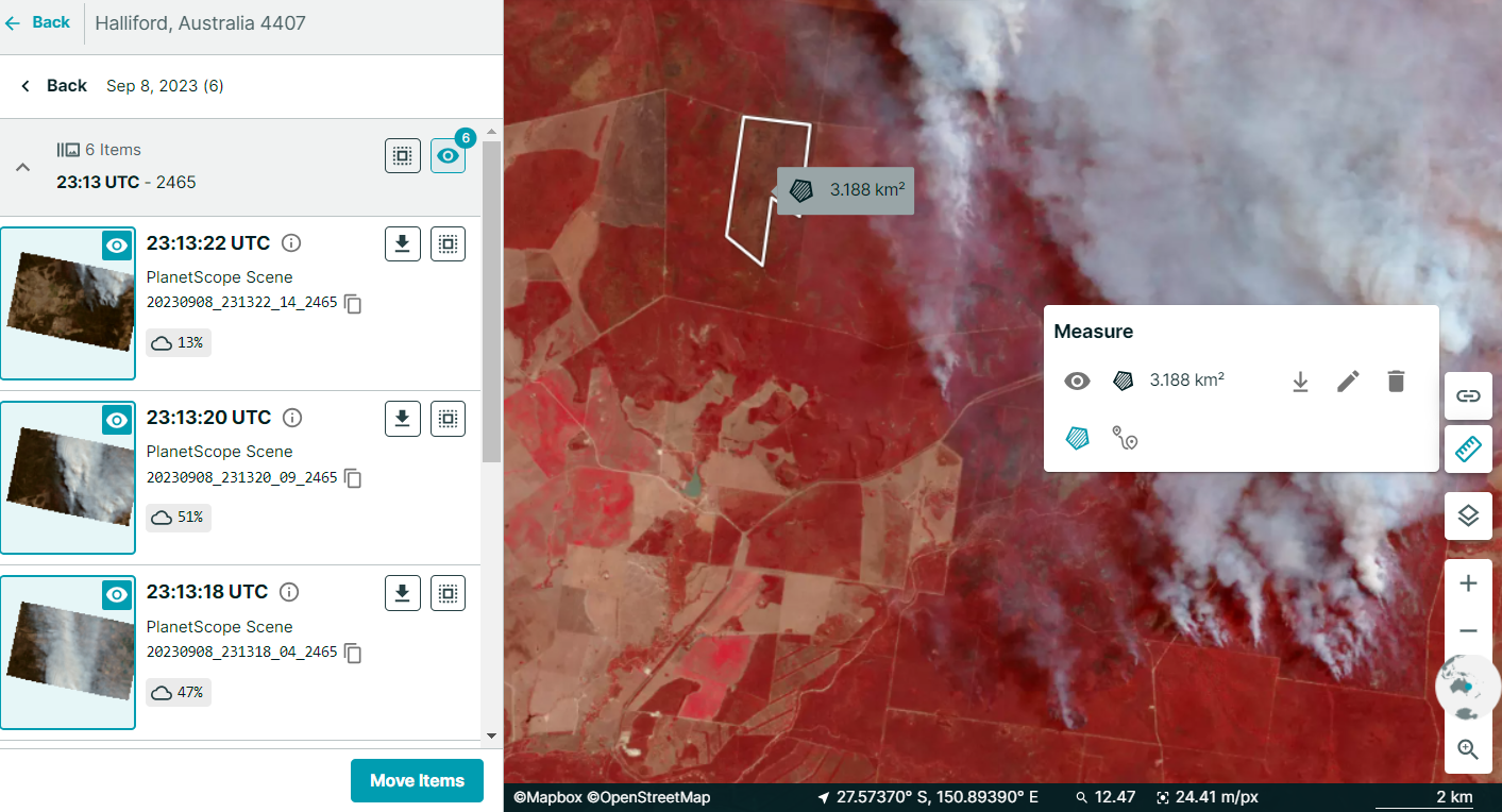
Bushfire events
Emerald QLD Fire | September 2023
The fire season in Queensland has begun, prompting residents of rural towns like Emerald and Beerwah to consider returning to their homes cautiously after evacuating. Bushfires are unpredictable, and conditions can shift rapidly. Residents have received specific guidance to remain vigilant, particularly regarding potential hazards like burnt trees, embers on the ground, and fallen powerlines.The aftermath of a bushfire can bring about significant challenges, including power outages and disruptions to phone and internet connectivity. Moreover, the presence of smoke may linger several days following the fire’s containment.
Mount Banks (Blue Mountains) NSW Fire | December 2019
In the Summer of 2019, prolonged and extremely high temperatures with significantly reduced rainfall, extraordinarily low humidity and periods of high winds produced fire conditions and behaviours not seen on such a vast scale before in the Blue Mountains. Over 80 per cent of the national park in the Blue Mountains was impacted, with over 122 million mammals, birds and reptiles impacted.
Our very own Brittany Baker (Dahl) was part of the effort to distribute mapped projections of fire spread during this time. Brittany recalls the sky full of smoke during the event, with air pollution lingering as fires spread around the Blue Mountains throughout the summer.
Orroral Valley (Canberra) ACT Fire | January 2020
The Black Summer disaster continued into early 2020, with fires starting across ACT – including over 82,700 hectares of Namadgi National Park. Major fire events in this area, including the Orroral Valley Fire, impacted threatened ecological communities (alpine bogs), biodiversity (water quality for aquatic species, large gliders, threatened flora and fauna, fire-sensitive communities, hollow-bearing trees, aquatic and riparian habitat) and water quality (sediments and nutrients in water catchments) in the area.
The imagery from space before, during, and after the event provides insight into the fire’s behaviour and changes in vegetation. Post-burn scarring on the landscape can be seen, displaying a deep red hue in the imagery below.
Related Articles
Here are more related articles you may be interested in.
NGIS joins global space-based solutions provider CLS
Media Release | 27th January 2026 NGIS is excited to announce that the company will now be part of CLS (Collecte Localisation Satellites), a global leader in monitoring and surveillance solutions for our Earth. The acquisition marks a significant milestone for the Australian geospatial sector, bringing together NGIS’ world-class geospatial expertise with CLS Group’s expansive reach and innovative capabilities in space-based solutions. Beyond technology and commercial…The view from the Cuipo Tree: Rethinking Biodiversity Beyond Protected Areas
Biodiversity Biodiversity is often discussed in abstract terms, percentages protected, species at risk, and hectares conserved. Ecological networks operated at vast and local spatial scales. It lives at the intersection of forests and farms, rivers and roads, protected areas and working landscapes. Geospatial intelligence allows us to see these intersections clearly: to understand where species…The Future of Geospatial: Key Trends for 2026
The geospatial sector has evolved and rapidly grown over the past decade, and in 2026, its role within organisations is more critical than ever. What was once primarily used for mapping and visualisation has become a powerful intelligence tool, connecting data, places, and decision-making across industries. As organisations face increasing pressure to operate sustainably, manage…Streamlining ArcGIS License Management with Automation
The increasing complexity of ArcGIS licensing in recent versions has created challenges for organisations managing larger numbers of users with diverse needs. The legacy license manager for ArcMap and earlier versions of ArcGIS Pro, along with a small number of user types and roles, have now been superseded. ArcGIS Pro licensing has now been consolidated into ArcGIS Enterprise and aligned with user types, which themselves have more fine-grained licensing options. Overlaying this evolving licensing…