Empowering the Abu Dhabi Department of Municipalities and Transport in Traffic Monitoring and Flood Mitigation

Empowering the Abu Dhabi Department of Municipalities and Transport in Traffic Monitoring and Flood Mitigation

TraceMark™ Flow an NGIS Solution has helped the Abu Dhabi Department of Municipalities and Transport (DMT) in traffic monitoring and flood mitigation. During the heavy rain event in April 2024, TraceMark™ Flow proved instrumental in managing traffic disruptions and infrastructure challenges by providing real-time data and intuitive dashboards for swift, informed decision-making. Beyond traffic monitoring, TraceMark™…

Read article

NGIS and Google partner to amplify the impact of Public Sector organisations through Google Earth Engine

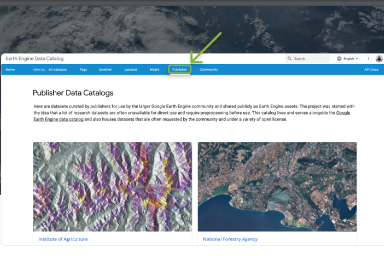
NGIS and Google partner to amplify the impact of Public Sector organisations through Google Earth Engine

NGIS and Google have launched the Earth Engine Publisher Program to enable the self-service delivery of high value Earth Observation data products from the public sector to a global community of users through the Earth Engine Data Catalog. The program aims to increase awareness and access to leading Earth Observation products globally through the Google…

Read article

Eight Reasons Why NGIS/MapsIndoors Should Map Your University Campus

Eight Reasons Why NGIS/MapsIndoors Should Map Your University Campus

In today’s rapidly evolving educational landscape, universities continually seek innovative solutions to enhance the campus experience for their students, staff, and visitors. One solution transforming how people navigate university campuses is the MapsIndoors solution brought to you by NGIS and our partner, MapsPeople. We’ve compiled eight reasons why MapsIndoors should be your university’s trusted mapping…

Read article

How NGIS enhanced REIWA’s property search with advanced GIS mapping

How NGIS enhanced REIWA’s property search with advanced GIS mapping

NGIS and the Real Estate Institute of Western Australia (REIWA) collaborated to update the  property hunting landscape on reiwa.com. As the leading representative of more than 85% of active agents in the state, REIWA aimed to elevate its online listings platform by incorporating advanced features and providing users with comprehensive and up-to-date property information. What…

Read article

NGIS creates an interactive battle hologram for Australian Defence Force

NGIS creates an interactive battle hologram for Australian Defence Force

NGIS teamed up with Skyline and Axiom, the world leaders in hologram equipment, to create a Commander’s Augmented Reality Mission Support Application System (C-ARMSAS) as an innovative exploration of concepts for the Australian Army.  C-ARMSAS is a next generation technology that could be used to assist in mission planning, war-gaming, and execution capability. The holographic…

Read article

How 3D mapping software can help local councils

How 3D mapping software can help local councils

3D GIS software Skyline allows councils to evaluate the aesthetic, practical and environmental impact of a proposed project or natural event. This cutting edge technology provides a realistic 3D environment, above and below ground where users can build, edit, navigate, query and analyse data. Skyline provides solutions to local councils’ top problems: shadow analysis and sight calculations,…

Read article

Location technology gives public transport commuters a personalised experience

Location technology gives public transport commuters a personalised experience

Location technology is revolutionising the public transport industry by giving commuters real-time, personalised journey information, direct to their smartphones. It’s a customer service innovation that gives forward thinking transport companies and local governments the opportunity to increase patronage, improve goodwill and reduce customer dissatisfaction. Commuters have long been at the mercy of public transport failures….

Read article

Four ways mapping chemical spray helps councils and business

Four ways mapping chemical spray helps councils and business

For companies and council departments in charge of chemical spraying, including pesticides and weed killers, spray logging and mapping is fast becoming an indispensable business tool. The arduous task of keeping track of what chemicals have been sprayed where, when and in what quantities is made easy with spatial tools. That’s because the location of…

Read article

How can Governments transform customer service using their data?

How can Governments transform customer service using their data?

Using Data : A series on governments leading the way in executing innovation “Given the current fiscal constraints and increasing expectations and demands on government services, including for flexible and high quality online/mobile services, new and better uses of existing assets such as data are important now more so than ever.” – Department of Premier & Cabinet,…

Read article