Blog
Discover more about the impactful work we do globally.
Filter

NGIS briefed at Google Singapore
In January, the NGIS staff travelled to Singapore after being invited for a Google office tour and briefing on the evolution of Google Maps API. Three groups of NGIS people were invited to the regional headquarters of the tech giant, which is spread over three buildings and 10 floors. NGIS staff were given guided tours of…

Asset management made easier with spatial technology
The challenge of managing assets over a large area is made easier when you use spatial technology like location intelligence platforms and daily satellite imagery to help you detect events quickly and respond effectively. It might be simply working out what the most efficient route is for a worker to visit a sequence of…
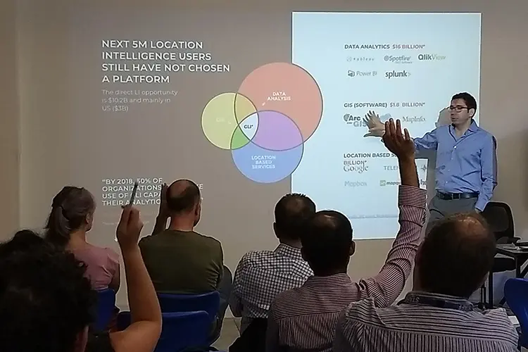
Carto: The latest trends in location intelligence
Location intelligence applications such as CARTO perform iterative, spatial analysis. CARTO optimises everyday strategic decision making and solves complex business problems on an interactive map. CARTO provides an easy to use, drag and drop interface to easily identify insights from large amounts of data. These insights can be rapidly deployed into applications and are easily customisable. NGIS partnered with CARTO to…

NGIS does Movember in style
NGIS Australia has completed another successful Movember, raising over $3800 in support of men’s health initiatives for the Movember Foundation. Team NGIS– Adam Mullett, Dion Fleming, Jack Green and Moreno Mattaboni, led by Richard Bentley and backed by the rest of the NGIS team, have spent the month of Movember growing out their best moustaches. …

Join our Carto breakfast event
Carto is one of the most exciting business intelligence tools in the cloud. It performs powerful location analytics to give you answers to your business questions. If you can use MS Excel, you can probably use Carto too with very minimal training required, harnessing the power of maps as a tool. Carto representative for Asia Pacific Fernando…
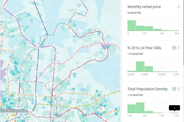
Enhance decision making by adding public data to your own
Augmenting your decision making with publicly available data to complement your own can lead to powerful business insight. You can gain this insight by analysing data you collect through your business processes using spatial technology. Combining it with relevant demographics and economics data gives you a heightened ability to make decisions based on the…

Mapping your business data for deep insight
Understanding the productivity of your sales regions, deciding where to focus on service improvement or working out which of your shops is covering too much ground on their own is easy when you see it as a picture. Maps help you establish relationships in your data that you would only see when presented as…

Planet partnership announcement
Daily satellite imagery of the whole globe is now available to NGIS customers through our new technology partner, Planet. NGIS Australia and Planet have established a new partnership, leveraging Planet’s extensive global daily imagery for NGIS’ developers and specialist teams. Planet can provide the capabilities and content for NGIS to build new solutions for a range of industries, as well as…

Four ways to get more from your license investment
Google Maps APIs power the location aspect of millions of apps and websites. When using the APIs in a premium use case, it is important to ensure that you’re getting the most out of your licence and aren’t using map credits inefficiently, without getting the benefits. Here are four things to consider if you’re concerned…

Google Travel Time powers Sydney variable message signs
Using Google travel time data, the New South Wales government have implemented a motorway messaging system that empowers motorists with the information they need to make decisions on the road. Whether to leave the motorway and take the back streets to avoid a traffic jam, or just know how long you will be on your…


