Gnarla Boodja Mili Mili

A living and interactive document sharing cultural knowledge
Gnarla Boodja Mili Mili (Our Country on Paper) was created by the WA Department of Local Government, Sport and Cultural Industries (DLGSC) Aboriginal History team. The initiative acknowledges the names of Noongar places throughout the Perth metropolitan area and is designed to be a living document that can be updated and expanded over time.
The research for the map was compiled by the department and launched in partnership with the City of Perth. The release coincided with the 2019 International Year of Indigenous Languages, which was declared by the United Nations General Assembly, in order to encourage urgent action to preserve, revitalise and promote Indigenous languages.
No central source for Noongar places or sites
Five years ago the department began receiving requests from schools in the Perth metropolitan area who were curious to find out more about Aboriginal places and sites around their schools.
“The interest from schools became a catalyst to find the information, but we decided to explore this more broadly. The information we needed was kept in many different places, so we knew there was a lot of work that needed to be done,” – Anna Wyatt, Director Aboriginal History.
As a result the Aboriginal history team embarked on a five-year research project to document and qualify Noongar place names spanning from Yanchep to Rockingham. In early 2019, the team committed to a firm deadline to launch the project and present their research for the City of Perth area on a public-facing map.
Aboriginal knowledge in a modern, digital setting
The DLGSC Aboriginal History team had worked with GIS analysts previously to commence the plotting of Aboriginal places and sites on a map. However, with the deadline of September 2019 on the horizon, they needed to find a suitable partner to complete the digital map within the time frame.
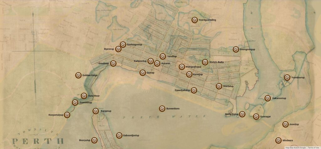
The Empired and NGIS teams worked in partnership with the DLGSC to design, develop and publish the Gnarla Boodja Mili Mili website, an end-to-end solution that shows the information collected by the DLGSC’s Aboriginal history team presented on a map of the City of Perth – spanning from Crawley in the west (Koolyamulyup) to Victoria Park (Mindeera) in the east.
NGIS and Empired sourced an archival map from the State Records Office of Western Australia that showed the City of Perth’s original swamplands. This was overlaid with Google Maps to reveal 21st century streets and built infrastructure. The map shows intrinsic Aboriginal knowledge in a modern, digital setting and provides a detailed, pre-colonial Aboriginal place naming map of Whadjuk country.
A map was the easiest way to show the information and research we had gathered, it was a natural extension of the work we had done”
– Mark Chambers, Senior Research Officer, DLGSC, Aboriginal History.
A truth-telling piece for the Noongar-Whadjuk people
NGIS and Empired sourced an archival map from the State Records Office of Western Australia that showed the City of Perth’s original swamplands. This was overlaid with Google Maps to reveal 21st century streets and built infrastructure. The map shows intrinsic Aboriginal knowledge in a modern, digital setting and provides a detailed, pre-colonial Aboriginal place naming map of Whadjuk country.


