Mobile first mapping applications

Roads and maritime updates in the palm of your hand
New South Wales Roads and Maritime Services (NSW RMS) are responsible for the building and maintenance of the road infrastructure, as well as compliance and safety monitoring for the roads and waterways across New South Wales.
The work by NSW RMS drives over 12 million visitors to their website every year with over 50% of engagement stemming from a mobile devices. Community stakeholder behaviour has evolved and as a result, people expect up-to-date and relevant information that can be accessed at anytime, anywhere.
NSW RMS engaged NGIS in 2015 to provide a technology assessment following the deprecation of the Google Maps Engine (GME) and have since been working closely to provide NSW RMS with mapping solutions that adopt a mobile-first policy.
Finding alternatives for a deprecated technology
NSW RMS approached NGIS when it was announced in January 2015 that the Google Maps Engine, a platform used to host a range of critical solutions, was being deprecated.
To assist in finding a replacement, NGIS performed a technology assessment with a view to understand the environment in which NSW RMS operated and assess the suitability and criteria of alternative digital mapping solutions to ensure they were equipped with the key functions NSW RMS required of a platform.
NGIS recommended CARTO as the replacement mapping technology for NSW RMS due to its flexible functionality, including:
- Integration of data from various sources
- Lightweight, intuitive dashboards
- Simple sharing of insights to stakeholders
Furthermore, CARTO enabled NSW RMS to reduce the number of programs they were using to operate and manage information.
In terms of skill and expertise that has been delivered by ngis, it has helped us immeasurably in the past few years.”
Tim Sinclair, Principal Manager, Digital Customer Experience, NSW RMS.

Maps migration built for multi-screen consumption
NSW RMS identified which of their projects utilised the Google Maps Engine and prioritised those that needed migrating across to CARTO. NGIS helped RMS procure, setup and migrate prioritised projects across to CARTO without having to build a bespoke solution.
NGIS remains on hand to ensure that any NSW RMS maps are fully mobile phone responsive, fulfilling NSW RMS’ requirement for their applications to have a seamless and simple user experience.
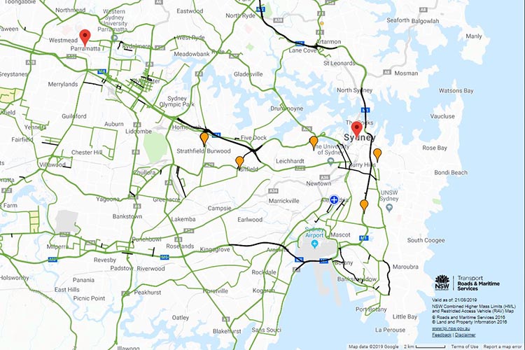
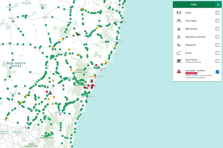
Mapping heavy vehicle routing
A key initiative was the Restricted Access Vehicle Map, a business-critical solution that was the first project to migrate across to CARTO. The Restricted Access Vehicle Map is a legal requirement for NSW RMS to provide information about which roads heavy vehicles can travel on across New South Wales. The Restricted Access Vehicle Map is accessed on average 365 times per day (133,000 times per year).
Given that the users of the map likely need to access its information while they’re stopping and starting on a route, they have the convenience of accessing it on their phone to receive the most up-to-date information at a glance.

Best practice digital communications for infrastructure management
NSW RMS now has multiple internal and external mapping solutions, fit for consumption on every screen. The partnership between NSW RMS and NGIS Australia has paved the way for best practice in the building and maintenance of future NSW RMS mapping projects.