MapsIndoors Venue Mapping
World-leading technology providing seamless ‘outdoor-to-indoor’ digital wayfinding solutions.
Does your business need help creating MapsIndoors?
Is your business in need of an interactive digital map and navigation solution for your venues? If you require a highly visual and functional mapping solution that enables users to easily and effectively find places inside your venue, then MapsIndoors is for you.
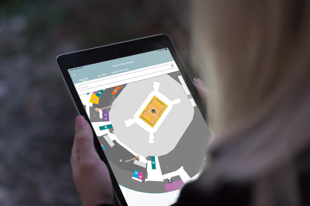
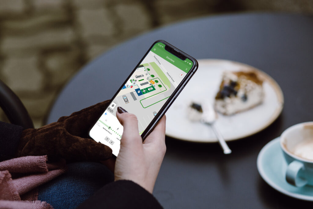
MapsIndoors is a world-leading technology that provides seamless ‘outdoor-to-indoor’ wayfinding solutions for businesses, universities, mining camps, stadiums, entertainment areas, airports, and hospitals. Built on Google Maps, it offers unparalleled consumer adoption, as Google Maps is used by a billion people worldwide every month.
Consumers can search, find, and navigate to locations inside your venue from the palm of their hand. NGIS will manage the entire process for you, serving as your local point of contact from design through implementation, and you will continue to receive support from the NGIS team throughout your contract.
How MapsIndoors makes navigation easier for your customers and employees
Customised to suit your needs
MapsIndoors can be tailored to meet your specific requirements and can integrate with almost any third-party data or booking system. Customise MapsIndoors with features such as:
- Turn-by-turn navigation
- Define preferred routes
- Block areas for user roles
- Route design for accessibility
Full Control
You can edit and update your maps and wayfinding platform in real-time, ensuring you are always in control.
Proven Technology
Currently used globally in venues including stadiums, airports, universities, hospitals, and convention centres, as well as private outdoor facilities such as amusement parks, holiday resorts, shows, and sports events.
Built on Google Maps
MapsIndoors is built on a single platform with Google Maps, providing a seamless transition from outdoor to indoor navigation, making it easier for your employees or customers.

Newsroom
Using the power of geospatial, NGIS is committed to enacting positive change for businesses, communities, and individuals, globally. Read our blogs to discover more about the work we do.
Celebrating Women in GIS: More than Maps
From tracking deforestation to building geospatial tools from the ground up, the women at NGIS are driving impactful real-world outcomes. This International Women’s Day, we spoke to three women across our Earth Observation, software engineering and spatial analysis solutions, to find out what first attracted them to GIS, what keeps them here, and what they’d tell their younger selves starting out.NGIS joins global space-based solutions provider CLS
Media Release | 27th January 2026 NGIS is excited to announce that the company will now be part of CLS (Collecte Localisation Satellites), a global leader in monitoring and surveillance solutions for our Earth. The acquisition marks a significant milestone for the Australian geospatial sector, bringing together NGIS’ world-class geospatial expertise with CLS Group’s expansive reach and innovative capabilities in space-based solutions. Beyond technology and commercial…The view from the Cuipo Tree: Rethinking Biodiversity Beyond Protected Areas
Biodiversity Biodiversity is often discussed in abstract terms, percentages protected, species at risk, and hectares conserved. Ecological networks operated at vast and local spatial scales. It lives at the intersection of forests and farms, rivers and roads, protected areas and working landscapes. Geospatial intelligence allows us to see these intersections clearly: to understand where species…The Future of Geospatial: Key Trends for 2026
The geospatial sector has evolved and rapidly grown over the past decade, and in 2026, its role within organisations is more critical than ever. What was once primarily used for mapping and visualisation has become a powerful intelligence tool, connecting data, places, and decision-making across industries. As organisations face increasing pressure to operate sustainably, manage…


