Using Earth Observation to monitor floods with Planet imagery

Australia is experiencing a widespread flooding crisis. From heavy rainfall in Northern and Central Queensland, rising waters in New South Wales and South Australia, to ongoing major flooding in Western Australia – the rains are causing havoc all over the country.
While floods can bring welcome relief for ecosystems suffering from drought, they pose a serious risk to the lives and livelihoods of those affected. They are also estimated to be the most expensive natural disaster in Australia – with a cost of $3.5 billion in 2022, and several billions more forecast for Government spending and insurance bills in 2023.
NGIS have responded to several devastating disaster events this summer, providing a full picture of the flooding events from space. Visualising imagery of an affected area from a bird’s eye view allows for a comprehensive understanding of the scope and severity of a flood. This information can be used to make more informed decisions about evacuation routes, emergency response efforts, and potential damage assessments.
Our imagery partner Planet has provided timely and analysis-ready satellite imagery of each event. Founded in 2010 by three NASA scientists, Planet designs, builds, and operates the largest Earth observation fleet of imaging satellites, capturing over 30 TB of data per day. Planet currently operates two satellite constellations; their Dove satellites, which provide a daily scan of all the Earth’s landmass at 3-meter resolution, and their SkySat tasking satellites, which capture tasked images at 50 cm resolution of any location on Earth.
The beauty of these two constellations is that they offer imagery when it’s needed most anywhere in Australia. Together, with NGIS’ geospatial solutions and services, and Planet’s data, we are making this data visible, accessible, and actionable. For more information on how NGIS can help your organisation with Planet imagery click here.
Flooding events
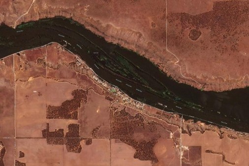
1. Flooding along Australia’s Fitzroy River and Kimberly region, Western Australia | January 2023
Termed the ‘worst in WA’s history’, the sheer scale of these floods smashed previous records in height and size. Although floods in this area are common, torrential rain and swells caused by Tropical Cyclone Ellie from December 23, 2022, submerged the landscape, like never before. Fitzroy Crossing was cut off by record high levels of floodwater, equivalent to two meters higher than the last record-breaking flooding event in 2002, and a flow rate equal to 20 years of Perth’s water use.
The impacts of the flooding left remote indigenous communities isolated, and hundreds of people in need of evacuation. The sheer size of the flooding made it difficult to capture data of the flooding events, as drone and aerial data collection was not a quick or effective option. Satellite imagery, such as daily PlanetScope imagery, provided an easy means to view the breadth of flooding, and provides an opportunity to view the destruction and clean-up as it occurs. The Western Australian Government continued the recovery process across the Kimberly region into February 2023.
2. Flooding along Central Darling, North New South Wales | December 2022
Fast rising flood waters caused major flooding and evacuation along the Central Darling, including the Menindee Township. Waters arrived down the river at a rate of more than 70 gigalitres per day into Menindee. Many residents in the area were left stranded, with their homes accessible only by boat and damages due to cost thousands of dollars. Further upstream, water continued to flow through Wilcannia, providing constant pressure to the lower system.
The ability to capture high-resolution SkySat images during the December 2022 flooding allowed for the NSW State Government to record the devastating impact the floods had on communities and the environment. No two floods are the same and can vary depending on the quantity, duration and location of rain falling – requiring responding agencies and Governments to collect data on a flooding event, when and where it occurs, to adequately respond.
3. Flooding at Younghusband, South Australia | January 2023
The southern end of the Murray-Darling Basin is subject to inundation, especially after excessive water and flooding in the river system further upstream. The La Niña weather event, which brought rain to eastern Australia for the past three years, continued into 2023 providing high water levels to many towns along the river’s end in South Australia.
Traditional methods of flood monitoring, such as ground surveys, can be time-consuming and dangerous in the midst of inundations. Satellite imagery, on the other hand, can be captured and analysed quickly and safely, providing up-to-date information to emergency responders and decision-makers. Planet imagery is an essential tool for understanding and responding to flooding. It provides valuable information that can be used to protect communities, save lives, and minimize the impact of floods on the environment and economy.
Visit Planet Stories for more imagery timelapses and examples of Planet’s work.
Related Articles
Here are more related articles you may be interested in.
How Satellite based Earth Observation Supports Emergency Response Teams
Natural disasters are an increasingly familiar reality, yet their unpredictability remains a core challenge. This is why preparedness is our best means of mitigating impact when disaster does occur. Satellite technology plays a critical role in enabling this readiness, but why? To understand this, you need only consider the sheer scale and diversity of Australia’s landscapes, waters and ecosystems. The continent spans 7.7 million square kilometres and, relative to its total area, has a low population density. This…United Nations, Google Cloud and NGIS Team Up to Bring AI-Powered Planning to Communities in Crisis
The United Nations International Organization for Migration (IOM), in partnership with Google Cloud and NGIS are advancing data-driven humanitarian planning through the use of AI and Geospatial powered tools, helping humanitarian organisations to analyse the most vulnerable locations across multiple areas and proactively plan for disaster response, climate driven displacement, and long term community recovery. At the centre of the initiative is the…Celebrating Women in GIS: More than Maps
From tracking deforestation to building geospatial tools from the ground up, the women at NGIS are driving impactful real-world outcomes. This International Women’s Day, we spoke to three women across our Earth Observation, software engineering and spatial analysis solutions, to find out what first attracted them to GIS, what keeps them here, and what they’d tell their younger selves starting out.NGIS joins global space-based solutions provider CLS
Media Release | 27th January 2026 NGIS is excited to announce that the company will now be part of CLS (Collecte Localisation Satellites), a global leader in monitoring and surveillance solutions for our Earth. The acquisition marks a significant milestone for the Australian geospatial sector, bringing together NGIS’ world-class geospatial expertise with CLS Group’s expansive reach and innovative capabilities in space-based solutions. Beyond technology and commercial…


