Improving Road Infrastructure Management with Location Intelligence


“Working with NGIS and the CARTO platform has made our day-to-day work more safe and efficient. We’ve overcome field challenges relating to asset identification and ensuring works are reported correctly.” Todd Munro, Asset Management Systems Coordinator, ConnectEast
The Client: ConnectEast
ConnectEast owns and operates the 39km EastLink toll road, Melbourne’s fastest and most delay-free freeway. The company has been awarded a 5 star ESG sustainability rating for six consecutive years by GRESB, and is considered one of the world leaders in sustainable transport infrastructure.
The Challenge: Upgrading from a paper-based method of asset management
ConnectEast has traditionally used a paper-based method of asset management. The ConnectEast team found the system outdated, inefficient and time-consuming. As a public infrastructure operator ConnectEast has the responsibility to service the road and its assets regularly to ensure high safety standards, continual traffic flow and valued public amenity. This process involved scanning and saving documents, transcribing them into the system manually or in the case of photos uploading them. ConnectEast needed an upgrade.
Results: Using Location Intelligence for better day-to-day maintenance
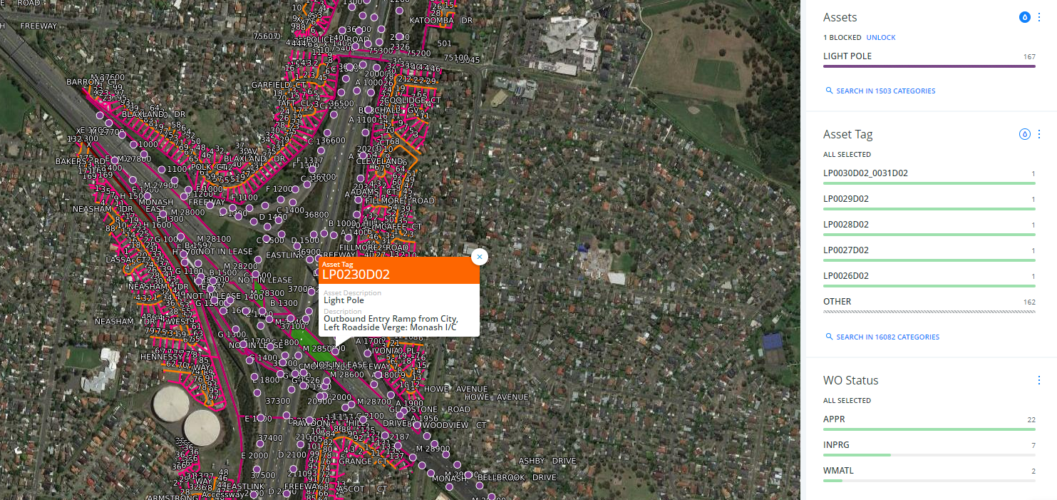
NGIS was contracted to build a Location Intelligence solution based on ConnectEast’s assets.The map visualization, developed using the CARTO platform, leverages valuable Location Intelligence to physically identify all assets using GPS data, each identified by a unique asset number. The desktop and mobile application feature a search function, allowing assets to be searchable on the map. This approach helps to eliminate any confusion about what asset has required work or unplanned maintenance. Our team of geospatial analysts was able to deliver a solution for ConnectEast, whereby office staff, field service technicians and maintenance crews are able to access asset and work order information.
Why CARTO and NGIS?
CARTO’s leading Location Intelligence technology and expertise of the NGIS team
As a CARTO reseller in Australia and New Zealand NGIS is able to provide support, licensing and application development to bring CARTO’s functionality into business projects, all in-house.
With the combination of CARTO’s technology and the expertise of the NGIS team, this case study was able to demonstrate that with a focused use case, spatial data and analytics can accelerate digital transformation and lead to significant real-world operational improvements.
Related Articles
Here are more related articles you may be interested in.
Celebrating Women in GIS: More than Maps
From tracking deforestation to building geospatial tools from the ground up, the women at NGIS are driving impactful real-world outcomes. This International Women’s Day, we spoke to three women across our Earth Observation, software engineering and spatial analysis solutions, to find out what first attracted them to GIS, what keeps them here, and what they’d tell their younger selves starting out.NGIS joins global space-based solutions provider CLS
Media Release | 27th January 2026 NGIS is excited to announce that the company will now be part of CLS (Collecte Localisation Satellites), a global leader in monitoring and surveillance solutions for our Earth. The acquisition marks a significant milestone for the Australian geospatial sector, bringing together NGIS’ world-class geospatial expertise with CLS Group’s expansive reach and innovative capabilities in space-based solutions. Beyond technology and commercial…The view from the Cuipo Tree: Rethinking Biodiversity Beyond Protected Areas
Biodiversity Biodiversity is often discussed in abstract terms, percentages protected, species at risk, and hectares conserved. Ecological networks operated at vast and local spatial scales. It lives at the intersection of forests and farms, rivers and roads, protected areas and working landscapes. Geospatial intelligence allows us to see these intersections clearly: to understand where species…The Future of Geospatial: Key Trends for 2026
The geospatial sector has evolved and rapidly grown over the past decade, and in 2026, its role within organisations is more critical than ever. What was once primarily used for mapping and visualisation has become a powerful intelligence tool, connecting data, places, and decision-making across industries. As organisations face increasing pressure to operate sustainably, manage…


