How NGIS enhanced REIWA’s property search with advanced GIS mapping

NGIS and the Real Estate Institute of Western Australia (REIWA) collaborated to update the property hunting landscape on reiwa.com. As the leading representative of more than 85% of active agents in the state, REIWA aimed to elevate its online listings platform by incorporating advanced features and providing users with comprehensive and up-to-date property information.

What was the problem REIWA faced?
REIWA faced the challenge of differentiating itself from its competition and providing users with a superior property hunting experience. The existing mapping system lacked advanced features and did not deliver the detailed property insights that the REIWA as an institute had access to through its research department. REIWA wanted a solution that would captivate users and offer them access to REIWA’s wealth of information, providing a comprehensive view of the properties and surrounding areas.
How did NGIS help?
NGIS worked closely with REIWA’s IT team to develop a scalable, responsive and intuitive web and mobile app based mapping solution. The collaboration involved using open-source data, integrating REIWA’s proprietary market research and incorporating user-friendly functionalities. NGIS used its expertise in geospatial analysis and data management to build an interactive mapping system that seamlessly integrated with the reiwa.com platform.
The mapping system includes a wide range of data sources, including LandGate, Google, REIWA and Department of Education, to provide a comprehensive view of properties.
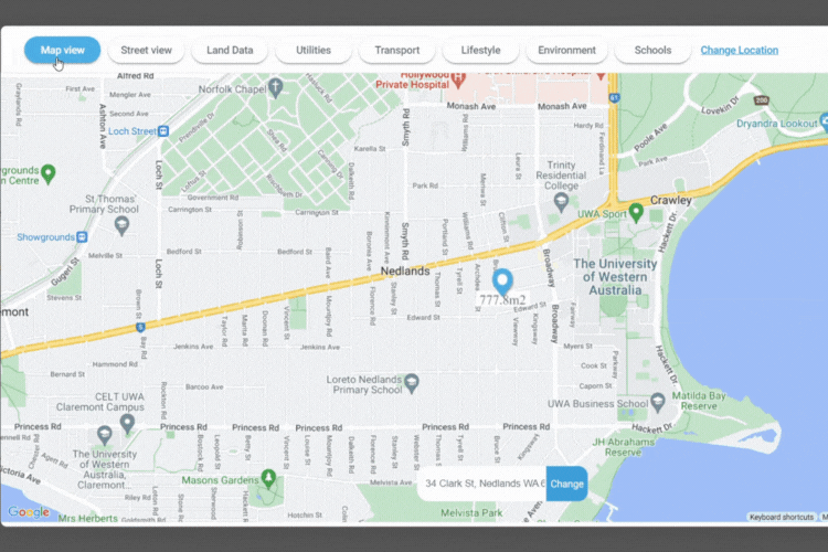
Transforming the property search experience
The new and upgraded mapping system, a key feature of the reiwa.com.au website and mobile app, empowers property hunters with valuable insights and information. The maps are simple and accurate, showing property, land dimensions, utilities (power and water), transport routes, nearby schools, lifestyle amenities, and a lot more.
The enhanced capabilities allows users to save significant time on research and avoid the need for multiple inquiries to different government departments. NGIS’s partnership with REIWA showcased NGIS’ ability to deliver cutting-edge geospatial solutions and address complex challenges in the real estate industry.
The integrated map is a game changer for property hunters – a key point of difference on the new reiwa.com.au site. NGIS worked in partnership with REIWA to resolve complex issues and bring this feature to life, with a professional, agile and flexible approach. We are delighted at the result of our partnershipREIWA CEO, Cath Hart.
Who is REIWA?
REIWA is the peak body for the real-estate sector, representing more than 85% of active agents across the state. Established in 1918, REIWA has been working towards improving the standards of the real estate industry in Western Australia for over a century.
With more than 100 years of industry leadership and local knowledge, REIWA provides real estate professionals and the public with data, insights and analysis to empower their property decisions.
REIWA had an aim to enhance its online listings site, www.reiwa.com, by incorporating advanced features that would provide property hunters with the most comprehensive and updated information. One of their key objectives was to develop an interactive mapping system that could showcase detailed property data, zoning information, utilities and planned changes to the area. NGIS turned this vision into reality.
Why NGIS?
NGIS is a leading provider of geospatial solutions with over 30 years of experience in the industry. With a team of highly skilled geospatial experts, data scientists, and software engineers, NGIS works closely with clients to deliver value-adding solutions that drive informed decision-making and unlock the full potential of geospatial data. Their proven track record of excellence, industry recognition, and extensive experience make NGIS the preferred choice for organisations seeking cutting-edge geospatial solutions.
Want to learn more?
Related Articles
Here are more related articles you may be interested in.
Celebrating Women in GIS: More than Maps
From tracking deforestation to building geospatial tools from the ground up, the women at NGIS are driving impactful real-world outcomes. This International Women’s Day, we spoke to three women across our Earth Observation, software engineering and spatial analysis solutions, to find out what first attracted them to GIS, what keeps them here, and what they’d tell their younger selves starting out.NGIS joins global space-based solutions provider CLS
Media Release | 27th January 2026 NGIS is excited to announce that the company will now be part of CLS (Collecte Localisation Satellites), a global leader in monitoring and surveillance solutions for our Earth. The acquisition marks a significant milestone for the Australian geospatial sector, bringing together NGIS’ world-class geospatial expertise with CLS Group’s expansive reach and innovative capabilities in space-based solutions. Beyond technology and commercial…The view from the Cuipo Tree: Rethinking Biodiversity Beyond Protected Areas
Biodiversity Biodiversity is often discussed in abstract terms, percentages protected, species at risk, and hectares conserved. Ecological networks operated at vast and local spatial scales. It lives at the intersection of forests and farms, rivers and roads, protected areas and working landscapes. Geospatial intelligence allows us to see these intersections clearly: to understand where species…The Future of Geospatial: Key Trends for 2026
The geospatial sector has evolved and rapidly grown over the past decade, and in 2026, its role within organisations is more critical than ever. What was once primarily used for mapping and visualisation has become a powerful intelligence tool, connecting data, places, and decision-making across industries. As organisations face increasing pressure to operate sustainably, manage…


