Multiteam geospatial enablement

Digital transformation for public transport
Metro Trains is Melbourne’s metropolitan rail service operating across 15 lines, 222 stations and transporting around 450,000 commuters daily.
In 2018, Metro Trains engaged NGIS to perform a strategic review of their current capabilities in geospatial information systems (GIS) and building information modelling (BIM) with a view to producing a roadmap for their future development.
A key driver for Metro Trains and the aim of the strategic review was to stay at the forefront of technology change and to ensure alignment with current and future government and industry policies, particularly in Digital Engineering.
Digital Engineering has been a key focus area for the Victorian Government given the potential to minimise costs associated with the design, building, operating and maintenance of public infrastructure rail networks.
Identifying digital requirements
Metro Trains identified that parts of the organisation were using unsupported mapping technologies with the potential to introduce road blocks and reduce operational efficiency.
With a range of highly skilled teams using non-corporate mapping platforms, there was a perceived risk that teams may be using replicated, conflicted or fragmented datasets.
NGIS conducted a review for Metro Trains and provided recommendations to achieve a centralised GIS, BIM and ERP platform that can be managed within one corporate environment.
NGIS used the review to build a roadmap that focused on an improved GIS capability within Metro Trains, in support of their asset management systems in the future.

A centralised approach
Through gathering user requirements and assessing the tools available within the market, NGIS created a broad implementation roadmap based on gaps in Metro Train’s existing capabilities and the maturity of their existing GIS toolset.
NGIS worked together with Metro Trains by engaging with several user groups and gaining management support to confirm an approach using appropriate information communication strategies.
Each step in the strategy focused on important data governance and industry policies around accessibility, standards and the integration of new technologies.

NGIS aimed to promote the GIS and BIM capability within metro trains Melbourne and provide a pragmatic roadmap for future development during the strategic review.”
Oliver Looker, NGIS.
Paving the way for a unified GIS system
Metro Trains are increasing their capacity to address issues and to support decision making using a geospatial context that may not have been available previously.
A unified GIS, BIM and ERP platform will provide different business units across the company with access to centralised data using readily available tools to support their everyday activities.

NGIS was selected by the Research Service as its preferred partner through a request for proposal (RFP) process. A leading technology partner, NGIS helped the Research Service build a customised solution for their specific requirements using CARTO.
To provide MPs with data that is both useful and timely was the most important requirement of the map. The idea wasn’t simple, with variation and customisation a consistent challenge, the Research Service knew it needed a tailored and user-friendly solution.
NGIS’ Senior Software Engineer, Clinton Kimsing was able to deliver the Research Service a bespoke solution to make the data more accessible. After discussions with Daniel about the Research Service’s project requirements, Clinton created a template that would enable rapid production and deployment of maps in a matter of weeks. Furthermore, he trained Research Service staff on how to work with the different components of the template; ensuring elements like the legend and layers could be fit for purpose.
NGIS provided simple, user-friendly features for the solution, allowing employees to build by requirement and create maps that are accessible for consumption by MPs and the NSW public. Other capabilities included: custom search data, custom filters, customised legends, multiple layers and layer popups, social media links and configurable text descriptions.
Improved efficiency and accessibility
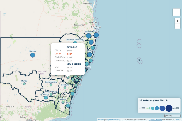
The map template is firmly embedded within operations at the Research Service, enabling employees to publish new and insightful data regularly. Recently, it published a map that illustrates the number of people receiving Youth Allowance and JobSeeker payments across NSW by State electorate.
Of the solution, Daniel reported that he was pleased to have a customisable template on hand for rolling out data in a timely fashion. In the future, the Research Service plans to use the template to publish a number of datasets on current political issues for public consumption.
We wanted to be able to build a map that made it easy for the user… I think it’s hit a sweet spot, so to speak, in terms of looking really professional while also meeting our time and technical capability restrictions.”
– Daniel Montoya, NSW Parliamentary Research Service.


