Unlock potential with Planet’s earth-imaging solutions
Planet is a global leader in high-frequency Earth observations. Building, and operating the world’s largest constellation of earth-imaging satellites. Capturing daily imagery of Earth, Planet makes global changes visible, accessible, and actionable through an API and online platform. NGIS, Planet’s Australian implementation partner, translates this data into operational value by leading technical delivery, user enablement, and organisational support.
Earth Observation Data Products
NGIS provides access to Planet’s comprehensive suite of satellite imagery and analytics products, designed to meet diverse monitoring and intelligence requirements. From daily global coverage and high-resolution site analysis to hyperspectral sensing and automated feature detection, these products deliver the data quality and temporal frequency needed for informed decision-making across government, defence, environmental, and commercial applications.
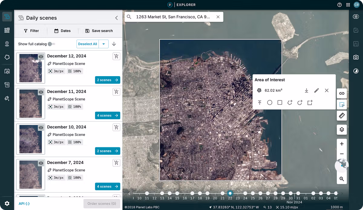
Daily Earth Observation at Scale
Monitor expansive areas and track evolving conditions across entire regions. With a constellation of hundreds of Dove® satellites capturing imagery almost daily, you’ll gain the temporal insights needed to identify patterns, spot anomalies, and respond to changes as they happen.
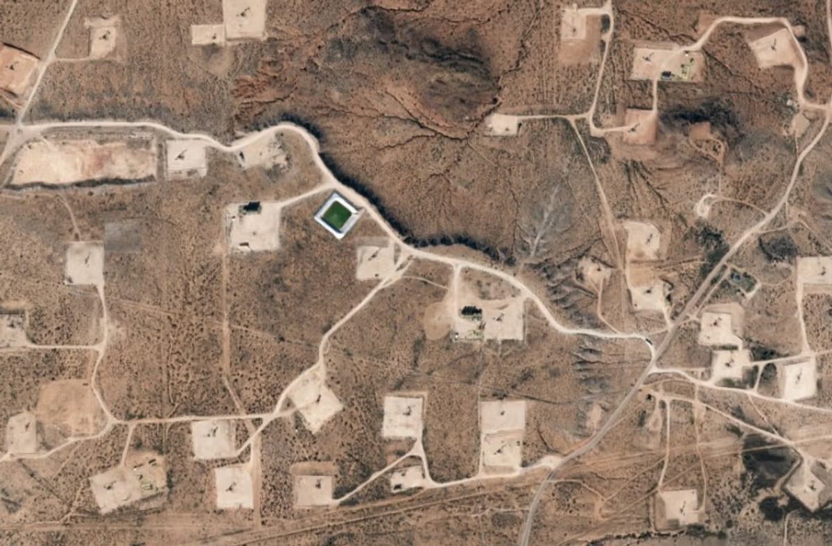
Detailed Site Intelligence
Access high-resolution data when precision matters most. SkySat® satellites deliver sharp imagery that reveals critical details, helping you spot emerging issues, reduce uncertainty, and act decisively when stakes are high.
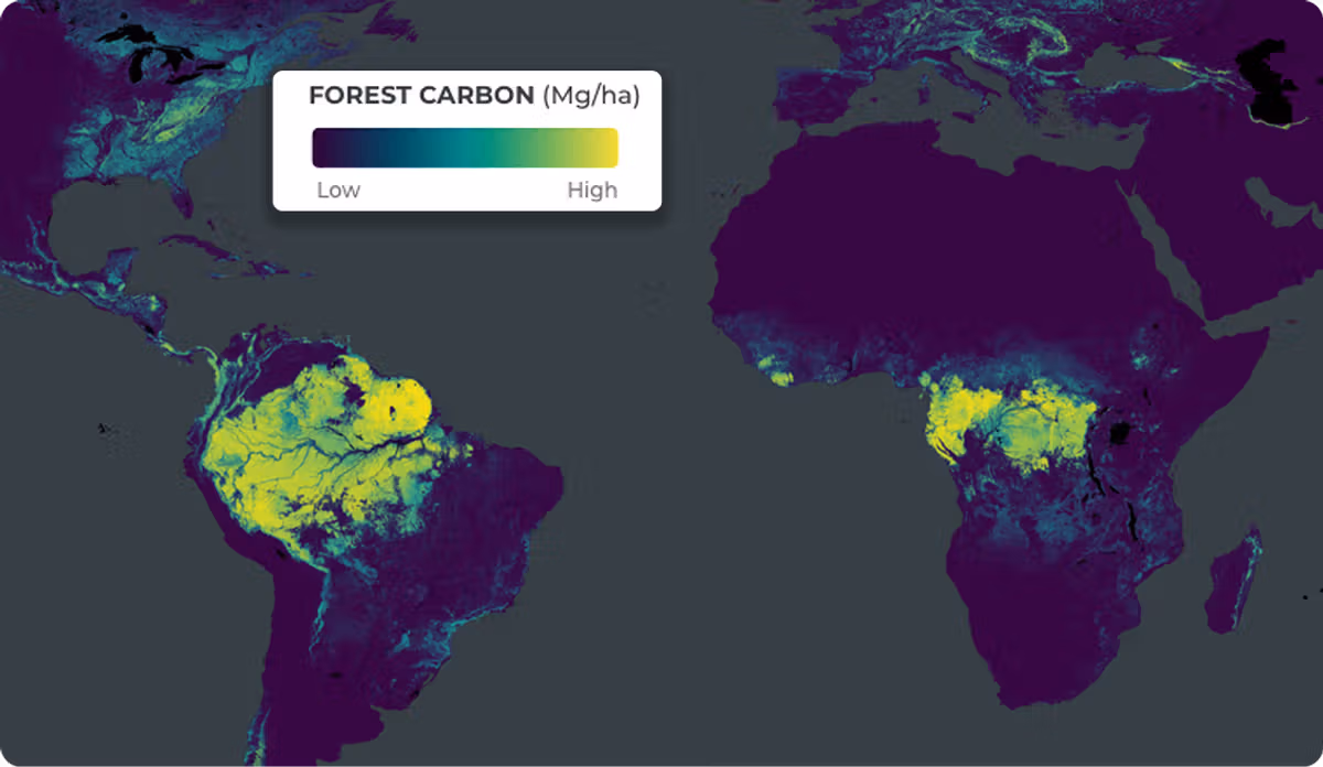
Scientific Environmental Monitoring
Transform satellite observations into quantifiable metrics. Planet’s data, combined with the broader Earth observation network, delivers scientifically validated measurements of key environmental indicators including soil moisture, biomass levels, and surface temperatures.
Automated Feature Recognition
Apply machine learning across Planet’s extensive archive to automatically detect and classify objects and features within monitoring data at a global scale. Focus your efforts where they matter most by accessing the latest intelligence without manually reviewing countless images.
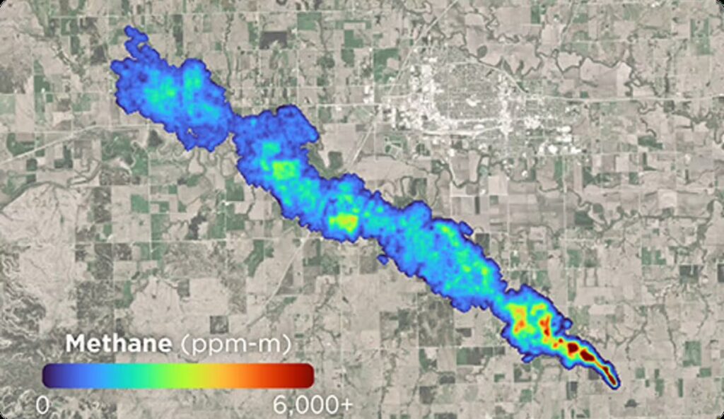
Hyperspectral Analysis Capabilities
Observe environmental factors beyond visible light. Tanager®, Planet’s hyperspectral satellite, measures across 400+ spectral bands to enable methane and CO2 detection, vegetation species mapping, water quality assessment, and other advanced applications.
Sectors
Make better decisions with better information. Understand what is happening on the ground in the areas you care about. Power your decision making with Planet’s unique, global dataset.

Government
Access timely Earth observation data that supports evidence-based policy development, program delivery, and informed decision-making across federal, state, and local government agencies.
Sustainability
Meeting environmental commitments and regulatory requirements demands accurate measurement and transparent reporting of change. Planet’s data provides the spatial and temporal resolution needed to observe, quantify, and report environmental shifts as they unfold.
Energy and Infrastructure
Enhance operational oversight of critical assets, track competitor activities, and identify potential risks early to prevent disruptions and reduce financial exposure across energy networks and infrastructure projects.
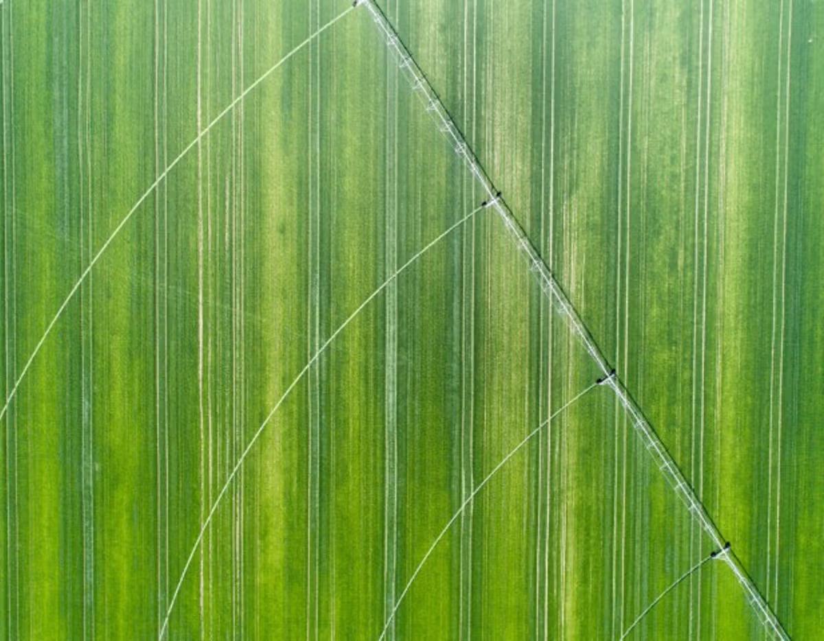
Agriculture
High-frequency satellite imagery and detailed spatial data enable farmers and agricultural managers to optimise production, improve profitability, and implement sustainable land management practices with confidence.
How Organisations Inform Decisions
with Planet Imagery
Environmental Monitoring
Real-time monitoring of bushfires, droughts, floods, coastal erosion, and land use change
Rapid Response
Faster and better-informed decision-making in planning, recovery, and compliance
Operational Visibility
Improved visibility for biodiversity conservation, urban development, and critical infrastructure
Agency Collaboration
Increased agency collaboration through a centralised, scalable imagery platform
Protecting giant kelp forests
Planet’s high resolution imagery is supporting The Nature Conservancy’s Giant Kelp restoration project in Tasmania, where 95% of underwater forests have been lost due to climate change over the past four to five decades. NGIS, funded by Google Australia through its $1 billion Digital Future Initiative, is using Planet satellite imagery combined with machine learning through Google Cloud Platform and partner expertise, to analyse and map canopy changes.
Professional services
Partner with NGIS
For over 30 years, NGIS has been an independent and innovative leader in geospatial solutions, delivering measurable impact for clients around the globe.
Since 1993, as a 100% Australian-owned company, we’ve grown to a team of over 100 experts accross seven locations worldwide. Our offering encompasses Enterprise GIS, Capability Building, Earth Observation Solutions and Geospatial Engineering solution.
Newsroom
Using the power of geospatial, NGIS is committed to enacting positive change for businesses, communities, and individuals, globally. Read our blogs to discover more about the work we do.
How Satellite based Earth Observation Supports Emergency Response Teams
Natural disasters are an increasingly familiar reality, yet their unpredictability remains a core challenge. This is why preparedness is our best means of mitigating impact when disaster does occur. Satellite technology plays a critical role in enabling this readiness, but why? To understand this, you need only consider the sheer scale and diversity of Australia’s landscapes, waters and ecosystems. The continent spans 7.7 million square kilometres and, relative to its total area, has a low population density. This…United Nations, Google Cloud and NGIS Team Up to Bring AI-Powered Planning to Communities in Crisis
The United Nations International Organization for Migration (IOM), in partnership with Google Cloud and NGIS are advancing data-driven humanitarian planning through the use of AI and Geospatial powered tools, helping humanitarian organisations to analyse the most vulnerable locations across multiple areas and proactively plan for disaster response, climate driven displacement, and long term community recovery. At the centre of the initiative is the…Celebrating Women in GIS: More than Maps
From tracking deforestation to building geospatial tools from the ground up, the women at NGIS are driving impactful real-world outcomes. This International Women’s Day, we spoke to three women across our Earth Observation, software engineering and spatial analysis solutions, to find out what first attracted them to GIS, what keeps them here, and what they’d tell their younger selves starting out.NGIS joins global space-based solutions provider CLS
Media Release | 27th January 2026 NGIS is excited to announce that the company will now be part of CLS (Collecte Localisation Satellites), a global leader in monitoring and surveillance solutions for our Earth. The acquisition marks a significant milestone for the Australian geospatial sector, bringing together NGIS’ world-class geospatial expertise with CLS Group’s expansive reach and innovative capabilities in space-based solutions. Beyond technology and commercial…


