GDA2020 explained for non-GIS people

If geospatial data and systems are deeply embedded into your work operations, you might have heard “GDA2020” muttered around hallways over the past year. That’s because it’s a bit of a big deal.
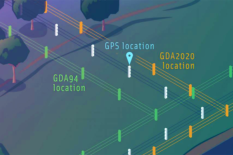
In late 2017, GDA2020 (Geocentric Datum of Australia 2020) was gazetted as Australia’s official datum – and the existing datum, GDA94, was revoked. As a result, organisations are now required to migrate their spatial data assets to the new geodetic datum – GDA2020.
Government departments and private sector organisations in Australia are now considering their strategies for the migration of various systems and data assets to GDA2020. This data migration is important for organisations that immediately want to take advantage of having sub-decimetre coordinate accuracy when capturing high accuracy data.
So, let’s quickly wrap our heads around why these changes are happening…
First, it’s important to understand what a geodetic datum is and what geodetic networks are.
Every country has its own datum. A geodetic datum consists of a network of well-defined reference points, a reference surface, and a coordinate system that enables a point on the earth’s surface to be uniquely identified by its latitude, longitude, and height.
Geodetic networks provide the practical realisation of the datum and form the fundamental reference framework for all spatial datasets including cadastre, infrastructure (roads, rail, and pipelines), imagery, and fisheries boundaries. This predefined reference framework ensures that all spatial datasets are aligned.
Why is the datum changing?
The Australian Government committed funds to provide 10cm (or better) accurate positioning to anyone, anytime, anywhere in Australia. This is significantly better than the 5-10m accuracy currently achievable using GPS enabled devices.
To make this happen, the existing GDA94 – which is based on the International Terrestrial Framework ITRF1992 epoch 1994.0 – must be upgraded. This is because GDA94 is a static (plate-fixed) datum tied to a continental plate that is moving at a rate of approximately 7cm per year in an overall north-easterly direction.
Historically, location differences of a metre or so have not been an issue. This is due to the fact that Global Navigation Satellite System (GNSS) have traditionally only provided accuracy of 5–10m. Since then, however, two key things have happened:
- Australia’s tectonic plate, the Earth’s fastest moving continental plate, has moved about 1.5 metres northeast.
- Positioning technology has evolved considerably. This means that by 2020, Australia will have moved 1.8 metres northeast of where it was in 1994. Subsequently, this means that our measurements are no longer precise, and a more accurate datum – GDA2020 – is required.
What are the challenges my organisation might face in a GDA2020 migration strategy?
GDA2020 data migration poses challenges for organisations that have significant data volumes and data types with varying formats, multiple legacy data assets, mobile and web applications, and data created using different technologies and inconsistent practices.
What we are seeing at NGIS is that organisations generally have limited resources to undertake a data asset migration, while also continuing to undertake ‘business as usual’ activities.
What should we do before embarking on a GDA2020 migration?
We have several recommendations for organisations that’re commencing their GDA2020 strategy, but these are our top three tips to consider BEFORE you start your migration.
- Audit your current data assets
By conducting a thorough review and audit of all current data assets and data capture mythologies, you will be able to adopt a best fit for purpose strategy for your organisation. This will set your organisation on the right path from the get-go. - Understand if your systems will support GDA2020
Ensuring that your data capture and presentation technologies have the potential to support the GDA2020 datum is crucial before you proceed. You don’t want to get halfway through the plan and then realise you have systems that are not compatible. - Get the data in order
Developing a communication plan is a good way to ensure that decision makers are provided with consistent and accurate data at all times through the migration (NOT a mix of datums).
Think about partnering with a company that has done this again, again and again…
Our team has worked on several GDA2020 migration projects with our clients over the past year or two. If you need assistance, guidance and experience in dealing with your migration project, get in touch with our team.
We can find a time to chat about your project and get you started on the right foot.
Co-authors: Joy Miles and Krystle Dobson
Related Articles
Here are more related articles you may be interested in.


