Building a Google Maps business app? 5 things to ask your developer

Huge business gains can be made by building Google Maps for Work API into your process or product, but to avoid issues down the road, including billing and compliance violations, there are a few questions you should ask your developers during the design and build phases.
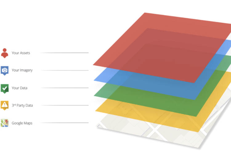
Maps can help you with team management, customer service, efficiency and business analysis by creating an easy to understand medium usable on any browser-enabled device. You can add your own business data to the Google Maps environment and get insight never before possible.
To avoid running afoul of the Google terms of service and acceptable use policies while ensuring you are stretching your investment as far as possible, there are five questions you need to ask your developer.
Do I need a licence?
On a weekly basis we meet clients who come to us with complaints about their developers or app-building company not informing them they needed a licence for their application. The annual licence for Google Maps for Work API is required when you have high external usage (public), any internal usage (private) or when the map is part of a software product you are on-selling to others.
Google’s rules are sometimes hard to decipher if you aren’t familiar with them and if you aren’t sure, it is better to ask NGIS rather than get caught out and have an unexpected bill.
Is my application compliant?
Compliance with Google’s terms of service can be another tricky area to navigate if you aren’t familiar with the way they are interpreted. Even when you do have a licence, there are many ways non-compliant to use the API, which can result in blocked service from Google. A common example is the storage of derived data such as geocoding, which is not allowed. There are also many grey areas of the terms of service and often a way of coding exists allowing you to get the answer you need without violation.
Am I getting the most from the APIs?
Despite the name Google Maps for Work API suggesting there is only one available, there are 13 APIs available to be used alone or in combination to derive an impressive array of results from your Google Map. Often a small additional investment in coding time can provide additional features with significant business benefit. For example, companies routing vehicles to jobs around the city might use the Directions API to give their drivers the best route, but taking live traffic data into account would give them a predicted arrival time and even suggest a better order to make the deliveries, allowing more to be made. There is also the Roads API, which gives managers the ability to check if drivers have been exceeding the speed limit.
Asking your developer if they know about all the APIs is a valuable activity. NGIS can examine your use case and advise on which functionality would support and enhance your current implementation.
Could I be using Google Maps in a more effective way?
A combination of the points above: understanding each of the APIs and what they bring to the table in functionality and understanding how licensing works, gives you the chance to maximise your investment. A simple example is looking at your usage and working out where you can use the Static Map API instead of the Javascript API. With Static Map API, you use one quarter of the credits and in many cases there is no extra functionality required that justifies spending more of your map credits.
If you’d like to see a detailed usage report for your app, NGIS can provide the data to you direct from Google’s engineers.
Are you working with knowledgeable developers?
Is your app or web company learning on your dollar? The Google Maps for Work API is relatively easy to use and implement. The quality of Google Maps and the ease of use both contribute to its ubiquity across internet applications, but there are shortcuts and learnings you need to have before you can create a truly great app.
NGIS has a large team of Google-recognised developers who have completed the training provided from Google. As a Google Maps Premier Partner (one of 24 globally) we are also privy to new features in beta becoming available in the near future. We are able to give you the best advice and produce effective and compliant apps.
Related Articles
Here are more related articles you may be interested in.
How Satellite based Earth Observation Supports Emergency Response Teams
Natural disasters are an increasingly familiar reality, yet their unpredictability remains a core challenge. This is why preparedness is our best means of mitigating impact when disaster does occur. Satellite technology plays a critical role in enabling this readiness, but why? To understand this, you need only consider the sheer scale and diversity of Australia’s landscapes, waters and ecosystems. The continent spans 7.7 million square kilometres and, relative to its total area, has a low population density. This…United Nations, Google Cloud and NGIS Team Up to Bring AI-Powered Planning to Communities in Crisis
The United Nations International Organization for Migration (IOM), in partnership with Google Cloud and NGIS are advancing data-driven humanitarian planning through the use of AI and Geospatial powered tools, helping humanitarian organisations to analyse the most vulnerable locations across multiple areas and proactively plan for disaster response, climate driven displacement, and long term community recovery. At the centre of the initiative is the…Celebrating Women in GIS: More than Maps
From tracking deforestation to building geospatial tools from the ground up, the women at NGIS are driving impactful real-world outcomes. This International Women’s Day, we spoke to three women across our Earth Observation, software engineering and spatial analysis solutions, to find out what first attracted them to GIS, what keeps them here, and what they’d tell their younger selves starting out.NGIS joins global space-based solutions provider CLS
Media Release | 27th January 2026 NGIS is excited to announce that the company will now be part of CLS (Collecte Localisation Satellites), a global leader in monitoring and surveillance solutions for our Earth. The acquisition marks a significant milestone for the Australian geospatial sector, bringing together NGIS’ world-class geospatial expertise with CLS Group’s expansive reach and innovative capabilities in space-based solutions. Beyond technology and commercial…


