Vanuatu Globe

The pacific islands are among the countries most vulnerable to sea level rise globally.
The Vanuatu Globe project was developed out of the Pacific Australia Climate Change Science and Adaptation Planning Program (PACCSAP) – a program funded by the Australian Government to help Pacific Island countries better understand and prepare for the potential impacts of climate change. NGIS was appointed by CRCSI to implement the capacity building component of the program.
Throughout 2013, NGIS attended several in-country scoping missions to determine each country’s requirements, and subsequently undertook a series of training programs to build the desired mapping capabilities of each respective government. To support this capacity building, NGIS also scoped the software and hardware required to effectively use the LiDAR data provided by the project. As a part of that capacity building, the program needed to provide the people of Vanuatu with access to the acquired data so they could increase awareness of sea level rising and coastal flooding, enabling effective planning and decision making.
Google Earth has been downloaded over 1 billion times worldwide. It is the most intuitive, familiar and easy to use mapping application available.
Nathan Quadros, Education and Business development manager, CRCSI

Lidar data to support capacity building
During the Vanuatu planning mission NGIS and CRCSI worked with the Vanuatu government to get buy in and support for Vanuatu Globe. Making the extremely valuable LiDAR (Light Detection and Ranging) data free, highly available and accessible was a new concept for the Vanuatu government, and a very different approach to climate change awareness.
Many Aid Programs have implemented software, but have taken little consideration for its accessibility and capability post implementation. NGIS and CRCSI were focussed on long term sustainability and ensuring that the high resolution data and inundation models were available to key decision makers and policy builders in Vanuatu on a medium that was familiar and easy to use.


Google maps engine cloud technology and training
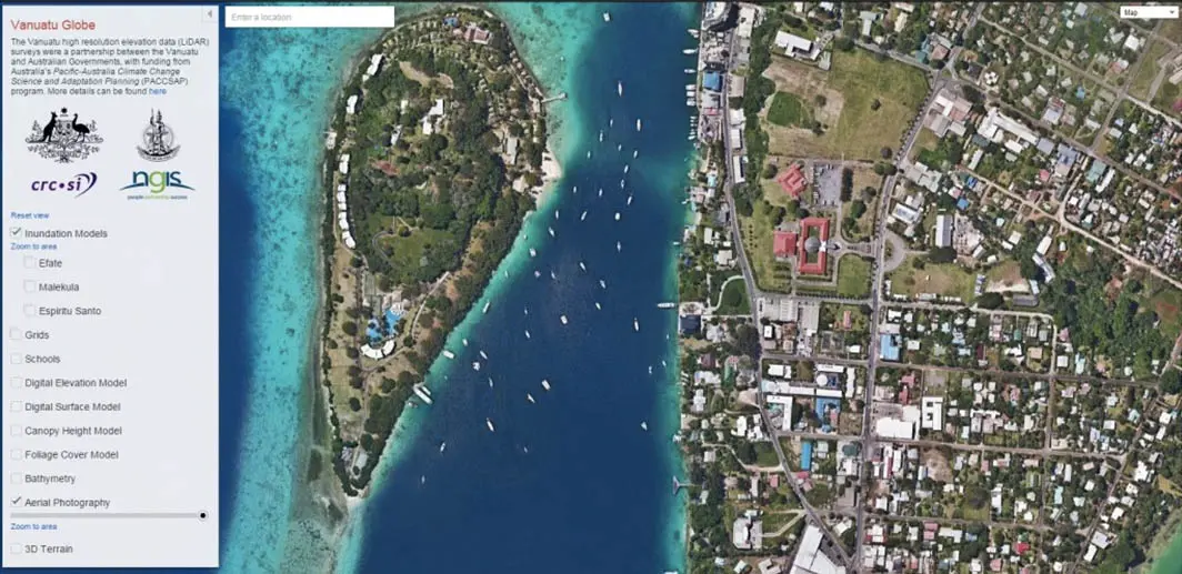
Using Google Maps Engine Cloud technology, the Globe provided consolidated access to a wealth of high resolution elevation data and aerial photography, including inundation layers to illustrate the predicted impact of sea level rise for Vanuatu. According to Nathan Quadros from CRCSI, Google Maps Engine was the obvious platform. “As a cloud based application, Google Maps Engine will allow the government of Vanuatu to focus on data dissemination and applications by having Google manage the Globe’s infrastructure and software”. The Vanuatu program focussed on creating awareness, use and distribution of valuable information, made possible by the recent internet fibre cable connected from Fiji. During the capacity building, training was provided on the Vanuatu Globe to ministry staff. Using Google Earth and Vanuatu Globe, the, “Climate Change Mapping for Teachers” course was delivered to help teachers increase climate change awareness.
Community implementation
The Vanuatu Globe provides high resolution data across Vanuatu with inundation layers for predicted sea level rise and coastal flooding scenarios for 2030, 2055 and 2090. The release of the Globe has provided the people of Vanuatu with an effective planning tool giving the government insight into the challenges the islands of Vanuatu face when adapting to climate change. Many Pacific Islands countries are now implementing a range of measures to mitigate the impacts of storm surge and inundation, including sea walls and mangroves. These measures also allow government ministries to focus policies, planning and development for change mitigation. “The Vanuatu Globe is going to change how planning is done in Vanuatu to accommodate the effect of climate change and the disaster risk reductions and considerations,” said Brian Phillips, Manager of the National Advisory Board on Climate Change and Disaster Risk Reduction in Vanuatu.
Climate change is a fact. And when our children’s children look us in the eye and ask if we did all we could to leave them a safer, more stable world, with new sources of energy, I want us to be able to say yes, we did.
President Barack Obama, State of the Union Address, January 28, 2014


